GeoPlatform Release Notes
June 2026 (Version 2.08.0)
Application
[Story: XGP-1277] GeoPlatform (plone/volto) mobile support for our components
Mobile Responsiveness Improvements - This release addresses multiple mobile usability and responsive design issues across GeoPlatform Volto.
Enhancements
Improved responsive behavior of the homepage hero section, including mobile-friendly scaling of the main title and search components.
Restored visibility of search filter labels on mobile devices to improve accessibility and usability.
Updated search input behavior to prevent placeholder text truncation on smaller screens.
Resolved layout issues that could cause horizontal scrolling on mobile devices.
Improved header responsiveness to ensure proper logo and hamburger menu placement across supported screen sizes.
Corrected alignment issues on NGDA Communities and GeoPlatform Hub pages for improved mobile presentation.
Fixed mobile navigation issues preventing the hamburger menu from displaying page navigation options on certain screens.
Verified continued support for responsive USWDS banner behavior introduced in previous updates.
Validation
Tested using Chrome DevTools Device Mode for:
iPhone 14
Pixel 7
iPad
Confirmed responsive behavior from 320px viewport width and above.
Verified no horizontal page scrolling and improved mobile navigation experience across tested pages.
[Story: XGP-1401] ITSOT Security Scan
[Story: XGP-1454] Add Summary Reports to 508 Compliance Tool
In order to easily understand the ADA 508 Compliance Status of a web site as a whole, we have added 2 summary reports. The first report provides the current score and total checks and failures for each web page checked.
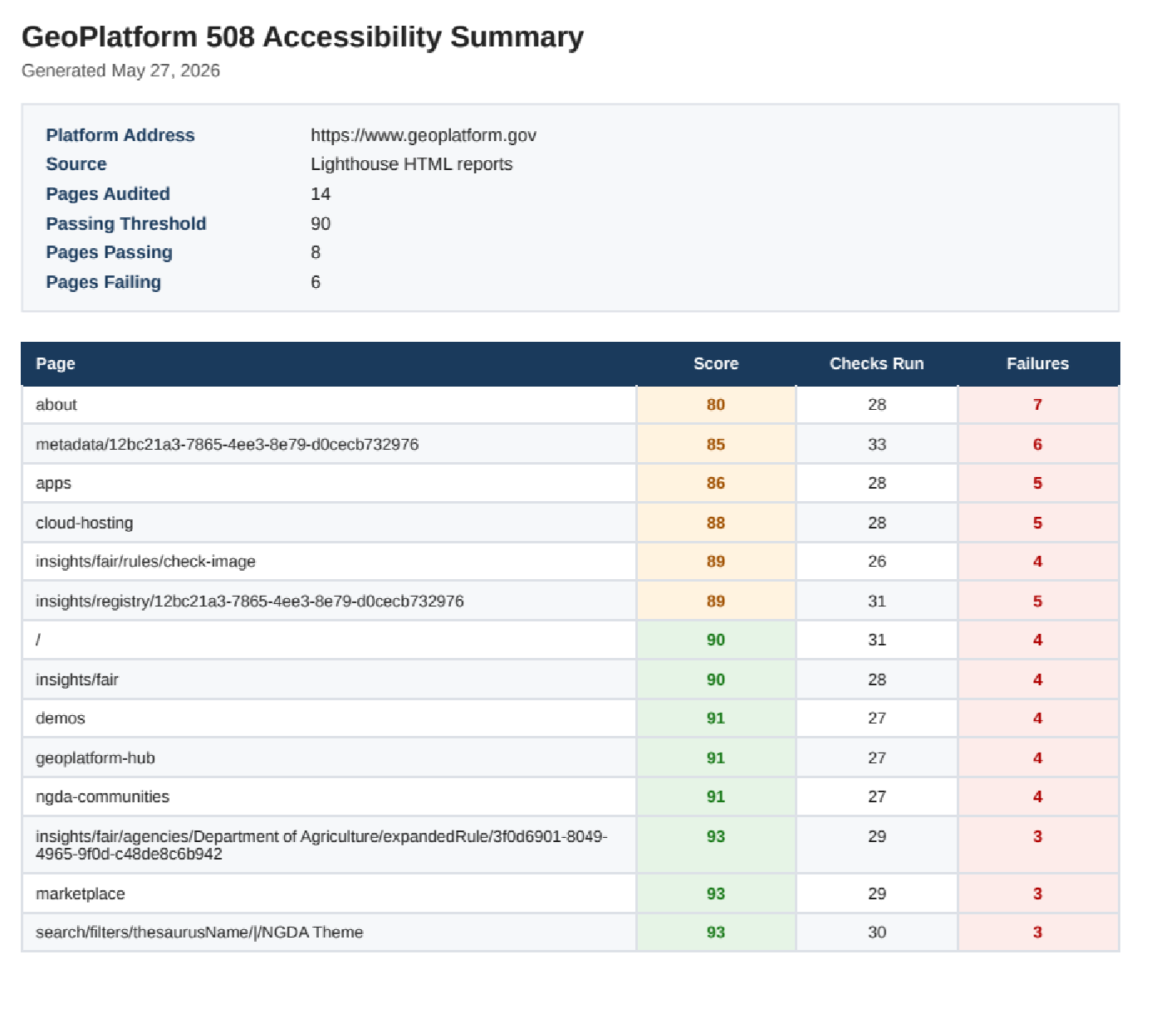
The second report provides provide more detail on which checks that a page failed for the pages that scores < the threshold score (usually 90).

Data
[Story: XGP-1471] Add Cache Metadata Size Check
Implemented a two-step size check for XML metadata downloads in the cache metadata lambda.
[Story: XGP-1506] Index Global Extents
Updated the GeoPlatform augment-json indexing logic so that global bounding boxes are no longer treated as invalid and filtered out.
[Story: XGP-981] Expand Augment Json to capture additional format paths
Expanded augment-json to capture additional ISO distribution format paths.
Infrastructure
[Story: XGP-1510] CHS Prod - Deploy and Update Pipeline
Deployed DataGov publisher harvest pipeline updates to the production environment.
[Story: XGP-1438] Runbook for security of the lambdas
Added lambda security runbook to GeoPlatform Wiki.
May 2026 (Version 2.07.0)
Application
[Story: XGP-1437] Make Volto GeoPlatform frontend environment-configurable for CHS deployments
Add
chs-devandchs-prdbuild environments to the Volto frontend using a build-time variable, replacing hard-coded SIT settings (API URLs, Keycloak client IDs) so CI/CD pipelines can produce environment-correct images without code changes.
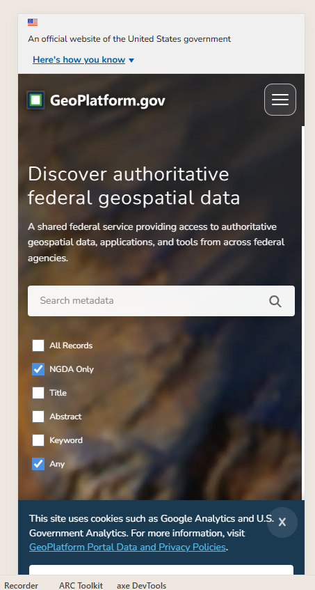
[Story: XGP-1345] Add USWDS banner to Geoplatform
Add the U.S. Web Design System (USWDS) official government website banner to the top of the GeoPlatform sites, matching the pattern used on Data.gov.
[Story: XGP-1343] 508 Compliance reports
Generate Section 508 compliance reports for GeoPlatform properties.
[Story: XGP-1324] April 508 lighthouse scan
Run Lighthouse accessibility scans on the GeoPlatform portal, knowledge base (kb.geoplatform.gov), and STAC browser (stac.geoplatform.gov).
[Story: XGP-1304] 508 compliance review and remediation for FAIR Insights and FAIR Insights Details pages
Review and remediate the FAIR Insights and FAIR Insights Details pages for Section 508 accessibility compliance using ARC and Lighthouse tools, addressing issues in custom Volto components.
[Story: XGP-1303] 508 compliance review and remediation for Registry Insights and Registry Insights Details pages
Review and remediate the Registry Insights and Registry Insights Details pages for Section 508 accessibility compliance using ARC and Lighthouse tools, addressing issues in custom Volto components.
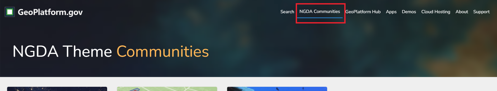
[Story: XGP-1302] 508 compliance review and remediation for About, Support, GeoPlatform Hub, and NGDA Communities pages
Review and remediate the About, Support, GeoPlatform Hub, and NGDA Communities pages for Section 508 accessibility compliance using ARC and Lighthouse tools, addressing issues in custom Volto components.
[Story: XGP-1301] 508 compliance review and remediation for Search and Metadata Details pages
Review and remediate the Search and Metadata Details pages for Section 508 accessibility compliance using ARC and Lighthouse tools, fixing issues related to search inputs, filter controls, and metadata content presentation.
[Story: XGP-1300] 508 compliance review and remediation for Homepage enhancements
Review and remediate custom Homepage enhancements for Section 508 accessibility compliance using ARC and Lighthouse tools, which may require component shadowing or updates to custom blocks.
[Story: XGP-227] Deploy Plone to DEV CHS Environment
Deploy the Plone application to the DEV CHS (Cloud Hosting Services) environment.
[Story: XGP-1288] Fix Minor Issues Plone/Volto Site vs Existing
Review and fix minor discrepancies between the Plone/Volto site and the existing site, including attempting to remove the default Volto top navigation path bar.
[Story: XGP-1314] Plone / Volto Fix Minor Issues
Fix the Plone favicon to use the correct GeoPlatform icon and make the homepage background continuous to match the existing SIT Angular site.
[Story: XGP-1282] Implement plug-in for Plone
Implement Plone-side OIDC authentication against Keycloak using the
pas.plugins.oidcplugin, including package installation, configuration, and verifying the end-to-end login flow for Volto.
Data
[Story: XGP-1444] EFS Cleanup on SIT
Migrate
plone-efsunderfargate-efsto match the DEV configuration, and remove duplicate EFS file systems and unused Volto access points on SIT.
[Story: XGP-1339] Update update-lmt-ngda to work with new DataGov Catalog
Update the
update-lmt-ngdaprocess to be compatible with the new Data.gov catalog.
[Story: XGP-1305] Update harvesting for new Data.gov catalog
Update the data harvesting pipeline to work with the new Data.gov catalog.
Infrastructure
[Story: XGP-1327] OpenSearch / Search API limits
Capped page size at 100 and enforced pagination limits to prevent errors when searching the GeoPlatform catalog.
April 2026 (Version 2.06.0)
Application
[Story: XGP-1200] Review IG audit findings
Review the Inspector General audit findings document and assess implications for the GeoPlatform project.
[Story: XGP-779] Remove FAIR from home page
Remove the FAIR section/component from the GeoPlatform home page.
Data
[Story: XGP-1202] Remove RDS Source Links for Sit, Dev, and Prod
Remove RDS source links appearing on the dataset-level registry insights page from the database across SIT, Dev, and Prod environments.
[Story: XGP-1201] Remove OpenSearch GP Service Links from Dev & Prod
Remove all GP Cache Service links from OpenSearch that appear on dataset search results and link to 404 pages.
[Story: XGP-1185] Remove Geoplatform NGDA services links from results page
Remove NGDA Service links that still appeared on the search results list after being removed from the dataset page.
[Story: XGP-1121] Monitor GeoPlatform NGDA Count
Implement automated monitoring of the official NGDA Portfolio count vs. GeoPlatform’s NGDA count, with Slack notifications via SNS when discrepancies are found.
Infrastructure
[Story: XGP-1144] Monthly AWS Burn Review
Conduct the monthly review of AWS spending and resource burn for the GeoPlatform project.
Services
[Story: XGP-1181] Fix 404 Data gov links in NGDA CSV download
Fix CSV downloads that generated broken data.gov links for manually inserted records by adding language indicating the dataset does not exist on data.gov.
March 2026 (Version 2.05.0)
Application
[Story: XGP-779] Remove FAIR from home page
Remove FAIR-related content or components from the GeoPlatform home page.
Data
[Bug: XGP-1202] Remove RDS Source Links for Sit, Dev, and Prod
Remove RDS-derived source links that appear as dataset-level registry insights so they no longer show as sources in the database.
[Bug: XGP-1201] Remove OpenSearch GP Service Links from Dev & Prod
Remove all GP Cache Service links from OpenSearch search results because they currently resolve to 404 pages.
[Bug: XGP-1185] Remove Geoplatform NGDA services links from results page
Remove remaining NGDA service links that still appear on the search results list, even though they’ve been removed from the dataset detail pages.
[Story: XGP-1121] Monitor GeoPlatform NGDA Count
Review the FGDC NGDA Portfolio and verify that all datasets are present on GeoPlatform, ensuring consistency between the official NGDA Portfolio count and GeoPlatform’s NGDA count.
Infrastructure
[Story: XGP-1254] Discovery for TVM findings not associated with system identifier
Currently TVM findings are appearing under notfount_notfound; to correctly map TVS scans to their own system identifier, EC2 instances must join AD and use AD-assigned hostnames instead of AWS-assigned hostnames.
[Story: XGP-1187] TVM scans / security patching
Apply security patches and TVM scan updates to address vulnerabilities.
[Story: XGP-1153] Weekly CHS Security scans report
Review TVM reports from the TVM folder and extract findings related to GPGOV accounts.
[Story: XGP-1116] Update GeoPlatform SSL certificate
Begin the renewal process for the *.geoplatform.gov SSL certificates for dev/qa/prod before their April 6, 2026 expiration.
[Story: XGP-1115] Review TVM (Tenable Vulnerability Matrix) report after ec2 is patched with newer AL2023 version
Review the 2026-02-19 TVM report, extract GeoPlatform-related findings, and send them to the project lead.
[Story: XGP-1114] Generate January Cost Burndown report for GeoPlatform AWS accounts
Generate GeoPlatform’s January AWS cost burndown in CloudCheckr and validate that it reasonably aligns with AWS Cost Explorer.
[Story: XGP-1111] Clean up SIT Cloudfront
Remove SPARQL, GeoAPI, and Terraform STAC distributions or paths from the SIT CloudFront configuration.
[Story: XGP-1008] Review and address CloudCheckr controls in PROD environment
Review CloudCheckr findings for the GeoPlatform PROD environment and remediate issues in line with CHS guidelines.
Services
[Bug: XGP-1186] Dataset status information missing from search results
Fix the augment-json pipeline so dataset status (e.g., completed, onGoing) is correctly extracted and populated instead of failing with a status normalization error.
[Bug: XGP-1112] Fix Paging Bug
Resolve the search API paging bug that causes one record to be skipped across paginated responses (e.g., 14 total results but only 13 unique records across pages).
[Bug: XGP-1181] Fix 404 Data gov links in NGDA CSV download
Ensure manually added NGDA records and other 404 cases show clear messaging that a corresponding data.gov dataset does not exist instead of linking to a broken data.gov URL.
February 2026 (Version 2.04.0)
Application
[Bug: XGP-1094] BLM Metadata Harvest Issue
Investigate and resolve why GeoPlatform’s BLM record count (584) does not match Data.gov’s count (763).
Data
[Story: XGP-1017] USGS Imagery NGDAs - Review Metadata
Investigate why USGS Imagery NGDA metadata checks are failing and recommend changes to satisfy metadata rules.
[Story: XGP-1016] Update Public API Get CSV Route
Update the NGDA CSV export route to include full Data.gov and GeoPlatform URLs and, when available, add NGDA ID as a column.
Infrastructure
[Story: XGP-1110] Service host security updates for dev and prod
Apply, patch, and test security updates on EC2 service hosts in dev and prod to address reported vulnerabilities and confirm the critical issues are resolved.
[Bug: XGP-1101] Bugcrowd Vulnerability
Address and resolve a vulnerability reported via Bugcrowd.
Services
[Story: XGP-1064] Update SIT Search API + Public API to use Cloudfront
Update the SIT Search API and Public API to route through CloudFront (aligning with dev and prod).
January 2026 (Version 2.03.0)
Stories
[XGP-45] Deploy EventBridge to CHS dev
[XGP-268] Audit Source Dataset CHS dev update
[XGP-1002] DOI NGDA harvesting update
[XGP-848] NGDA 152 update
December 2025 (Version 2.02.0)
Stories
[XGP-548] Add safeguards to ckan-to-geospatial-csv Lambda
[XGP-789] Add ‘43 U.S.C. Ch. 46’ link to footer supporting FGDC compliance
[XGP-276] Add scheduled Audit Source Dataset Open Search Clean up option
[XGP-849] Update NGDA Audit Scripts
Bugs
[XGP-800] Fix OpenSearch prod stability issues
November 2025 (Version 2.01.0)
Stories
[XGP-271] GeoPlatform live in DOI Cloud Hosting Services (CHS)
[XGP-195] Deploy update-data-pipeline-state to CHS dev and prod
[XGP-175] CloudFormation security updates
[XGP-194] Deploy update-lmt-ngda to CHS dev and prod
[XGP-192] Deploy ckan-geospatial-to-csv to CHS dev and prod
[XGP-191] Deploy audit-source-dataset to CHS dev and prod
[XGP-251] Deploy Fair Insights Lambda to CHS dev and prod
[XGP-196] NGDA Search update deploy to CHS dev and prod
[XGP-195] Deploy update-data-pipeline-state to CHS dev and prod
Bugs
[XGP-277] Fix broken KBase logo on sub-pages
October 2025 (Version - pre-release)
Stories
[XGP-182] Deploy Eventbridge to CHS dev and prod
[XGP-181] Deploy SQS to CHS dev and prod
[XGP-180] Deploy RDS-proxy to CHS dev and prod
[XGP-165] Deploy NGDA Search Update for CHS dev and prod
[XGP-164] Deploy Harvest Pipeline to CHS dev and prod
[XGP-190] Deploy augment-json to CHS dev and prod
[XGP-187] Deploy ingest-json-metadata to CHS dev and prod
[XGP-186] Deploy convert-dcat-to-iso-json to CHS dev and prod
[XGP-182] Deploy GP-Metasearch eventbridge to CHS dev and prod
[XGP-164] Deploy Harvest pipeline to CHS dev and prod
[XGP-207] Add NGDA Filter to home page
Bugs
[XGP-198] Fix Opensearch Role Name Mismatch
[XGP-177] Load missing NGDA records
September 2025 (Version - pre-release)
Stories
[XGP-94] Deploy Search API and API Gateway for GP Metasearch to CHS dev
[XGP-48] Deploy Public & Internal Search API Gateways to CHS dev
[XGP-38] Deploy gp.gov portal to CHS dev
[XGP-42] Deploy OpenSearch CHS dev
[XGP-41] Deploy RDS Proxy to CHS dev
[XGP-40] Deploy RDS Databases to CHS dev
[XGP-37] Deploy Bastion server to CHS dev
[XGP-139] Deploy public api deployment to CHS dev
[XGP-134] Deploy S3 buckets to CHS dev
[XGP-131] Deploy of Portal to CHS dev
[XGP-151] Deploy audit-source-dataset to CHS dev
[XGP-160] Add stg.goplatform.gov to CHS dev
[XGP-159] Upgrade Kbase to Sphinx latest version
April 2025 (Version 1.76.0)
Stories
GS-3749 Portal - NPM security updates
GS-3775 Search API security updates
GS-3785 Portal - CSS and JavaScript updates
GS-3776 Internal API security updates
GS-3799 S3 security updates
GS-3803 Portal security updates
GS-3804 STAC catalog updates
GS-3808 STAC security updates
GS-3809 KBase security updates
GS-3812 Data.gov CSV Manifest updates
Bugs
GS-3758 Extra NGDA data geometry type unknown
GS-3571 Search record count
March 2025 (Version 1.75.0)
Stories
GS-3718 Internal API - remove unused function
GS-3755 Public API - update packages
GS-3783 Route S3 content through CloudFront and make S3 buckets private
GS-3800 Update SSL Certificate
GS-3754 Update syncing NGDAs with Data.gov
GS-3777 Update syncing metadata with Data.gov
Bugs
GS-3658 Portal - “TYPES OF RESOURCES” Filter multiple checkboxes
GS-3748 Portal - Cookie X button not working
GS-3750 Portal - Display bug
GS-3758 NGDA - Geometry type unknown
GS-3759 NGDA - extract NGDA data driver
February 2025 (Version 1.74.0)
Stories
GS-2040 Improve performance and speed of frontend for SEO
GS-3419 Display coordinate values with bounding box
GS-3657 Update GP-Metasearch to support points using 4 coordinates
GS-3679 STAC API collection update
GS-3703 AuditSourceDataset clean up OpenSearch
GS-3720 Update GeoAPI contact information
GS-3722 Add STAC collection temporal and spatial extents
GS-3727 Update RDS parameter group
GS-3742 Update STAC collections
Bugs
GS-3161 CSDGM metadata original source
GS-3412 GenerateRasterTile
GS-3499 Metadata details page display of small spatial extents
GS-3743 DCAT processing
January 2025 (Version 1.73.0)
Stories
GS-3669 Portal build warnings optimization
GS-3027 Remove deprecated Insights API
GS-3677 Configure pg_cron
GS-3280 Update GeoAPI description
Bugs
GS-3582 Registry Insights UI issue
GS-3418 Update zoom level
GS-3695 DCAT Processing path update
GS-3407 Injest JSON update
GS-3678 GeoAPI sources pipeline
GS-3695 DCAT processing discrepancy
GS-3527 AugmentJson URL error handling
GS-3540 Status facet Indexing
GS-3714 GeoAPI configuration
GS-3599 NGDA Communities redirect
GS-3705 Backup LMT database
GS-3691 Insights download links rule
GS-3386 Check vocabulary codes against ISO code list
December 2024 (Version 1.72.0)
Stories
GS-3516 Add Leaflet metadata details sidebar
GS-3670 Portal build warning
GS-3673 Update CORS for STAC catalog.json
GS-3704 Upgrade PostgreSQL to version 14
GS-3234 Deprecate WordPress infrastructure
Bugs
Gs-3565 Update API endpoint to search by friendly ID
GS-3604 Search Page empty checkbox in status filter
GS-3523 Duplicate distributions
GS-3544 Pass source downstream for the magic pipeline
GS-3642 Lookups API returning incorrect GeoPlatform link
GS-3537 CSV NGDA null fields
GS-3623 Insights mismatch in total and recommended
GS-3607 STAC API missing collections
GS-3346 Duplicate tiles errors
GS-3544 Pass source downstream for the magic pipeline
GS-3651 Search results on cached services
GS-3428 GeoAPI - empty collections
November 2024 (Version 1.71.0)
Stories
GS-3127 Update node version for Terriamap
GS-3544 Pass source downstream for the magic pipeline
GS-3652 Update web pages with links to DOI privacy policy and accessibility policies
Bugs
GS-3155 GeoAPI - Header/Footer issue
GS-3608 Going back in browser after a search result doesn’t keep the search term
GS-3642 Lookup API returns incorrect GeoPlatform link
September 2024 (Version 1.70.0)
Stories
GS-3619 Update Terriamap version to latest version
GS-3520 Optimize database query for Search Registry Insights
GS-3614 CacheMetadata deletion function
GS-3628 Sources pipeline mimetype
GS-3643 Remove Metadata From Opensearch
Bugs
GS-3463 STAC - Catalog fetch failure
GS-3477 STAC - Navigation issues
GS-3494 STAC - UI issues
GS-3572 STAC - Image asset issues
GS-3583 Fix record detail page - Legal constraint display
GS-3635 Search hanging when no results returned
GS-3609 Search hanging on keyword search
August 2024 (Version 1.69.0)
Stories
GS-3597 GP-Lib tests update
GS-3606 Add Google Analytics to STAC
Bugs
GS-3598 Public API timeout
GS-3617 FAIR Insights materialized view not updated
July 2024 (Version 1.68.0)
Stories
GS-3492 Catch Esri metadata when downloading from DCAT
GS-3507 GeoServer Upgrade to version 2.25.2
GS-3563 Document local Webapi Setup and Usage with Geoplatform Lab
Bugs
GS-3415 FGDC Conformance Checklist / FAIR Insights not running
GS-3575 Whitespace not encoded for urls in augmentJSON
July 2024 (Version 1.67.0)
Stories
GS-3522 Populate GeoPlatform Services in AugmentJson
GS-3529 Improve JSON File Count Consistency in LMT
GS-3564 FAIR Insights review rescore-all script
GS-3594 AuditSourceDataset sync with LMT
Bugs
GS-3479 Registry Insights - Autocomplete takes more time than expected
June 2024 (Version 1.66.0)
Stories
GS-3373 ckanGeospatialToCsv account for first lambda failure
GS-3556 Backend - AuditSourceDataset
GS-3574 Injection: AuditSourceDataset
GS-3570 Injection: CKANGeospatialToCSV - IAM permissions
Bugs
GS-3391 prdWarning - prd-AuditSourceDataset
May 2024 (Version 1.65.0)
Stories
GS-3239 Cleanup S3 Deployment Buckets
GS-3364 Update header links in STAC and other applications
GS-3375 Update the cacheDatasetMetadata function to import-by-friendly-id
GS-3505 Remove GeoNetwork sections from Registry Insights Curation Tool
GS-3515 Update and standardise OpenSearch lambda roles
GS-3518 Cache-metadata-from-data-gov harvest
GS-3519 update-lmt-ngda
GS-3521 Add Sources into Pipeline
Bugs
GS-3305 Record detail page - Metadata Source Information does not scroll to correct viewpoint
GS-3316 Agency facet doesn’t show all agencies
GS-3385 Update Spatial and Temporal Extent Rule to support Time Instant
GS-3427 Fair Insights - Fair insights page on SIT does not display the data as expected.
GS-3465 Area of Interest does not fetch the results as expected
GS-3480 Fair Insights - UI issue
GS-3495 https://www.geoplatform.gov/ngda-communities redirect
GS-3500 GeoPlatform NGDA Cache Report
GS-3510 Update CacheMetadataFromDataGov DCAT linked geospatial metadata record logic
GS-3513 LSIB record doesn’t show records and links in Metadata Source Info
GS-3541 Status facets with a space in term not handled correctly
April 2024 (Version 1.64.0)
Stories
GS-3359 STAC Browser Remove external content functionality
GS-3416 DCAT spatial extent support for named places and GML extents
GS-3472 Record detail page - Legal Constraints
GS-3508 Update NGDA processing for portfolio table change
Bugs
GS-3193 sit-RulesEngineApiRunner
GS-3130 Clear keyword search
GS-3288 Prd version of stac.geoplatform.gov site is using SIT assets
GS-3309 Searched results are rendered even after navigating away from the page
GS-3314 Registry Insights links to the old GN Id and returns a 404
GS-3315 Home Page Broken Link
GS-3334 Fix cache-metadata-form-data-gov lambda to persist the XML Format to the database
GS-3342 Discovery- Clean up GP generated LSIB resources
GS-3484 When refreshing a Registry Insights Details page the page goes the the Registry Home page
GS-3493 Remove namespace error from cache-metadata
GS-3496 PRD STAC - communities tab from the menu on top, returns a 404 page
March 2024 (Version 1.63.0)
Stories
GS-3193 sit-RulesEngineApiRunner
GS-3200 sit-GenerateVectorTile
GS-3206 sit-GenerateUTFGridTile
GS-3208 sit-ReportSystemStats
GS-3269 Create lambda/script to run FAIR Insight Rules for all records
GS-3420 Increase bucket policy on Bulk lambda
GS-3426 Review CloudWatch Logs in SIT - Title Error
GS-3471 check opensearch in auditSourceDataset
GS-3482 Update home page and about page 404 URLs
Bugs
GS-3307 Record detail page - Issues identified under Records and links section
GS-3308 Search - Issues with the pills added to the record
GS-3347 Search results CSV download 404 error
GS-3488 [PRD] Search - Clicking on the last page button returns 400 error
February 2024 (Version 1.62.0)
Stories
GS-1666 Sync Terriamap Configuration Files with s3
GS-2859 Resolve Frontend Linting Errors - generate-portal-lambda
GS-2861 Resolve Frontend Linting Errors - Collections Components
GS-2862 Resolve Frontend Linting Errors - Metadata Components
GS-2863 Resolve Frontend Linting Errors - Metadata Insights Components
GS-2865 Resolve Frontend Linting Errors - Support Components
GS-2869 Resolve Frontend Linting Errors - Utils
GS-2930 POC: Opensearch Disaster Recovery
GS-2951 Remove jQuery from frontend
GS-2983 Search Results: Advanced search for records of no results
GS-2993 Implementation - Deprecate old GitHub Code
GS-3007 Develop and Deploy Complete - Search Optimize Lambda
GS-3008 Implement - Cutover
GS-3035 Add keywords for additional data cleanup
GS-3046 Develop and Deploy Complete - Registering Turtle Artifacts
GS-3047 Develop and Deploy Complete - UI Changes for Search Results
GS-3049 Add autocomplete functionality to the registry insights search component
GS-3050 Update the URL hydrating/building logic for the registry insights page
GS-3052 Develop and Deploy Complete - Implement proactive notification banner
GS-3054 Develop and Deploy Complete - Remove angular-bootstrap-md and replace with Angular Material
GS-3062 Update census stac based on their new WAF
GS-3063 Metadata page details overview map
GS-3064 GP cached services in opensearch
GS-3088 Develop and Deploy Complete - Add JSON-LD Formatter and Logic to gp-metasearch
GS-3093 Develop and Deploy Complete - GPT Search Embeddings - UI
GS-3094 Develop and Deploy Complete - GPT Search Embeddings - Vectors
GS-3095 Develop and Deploy Complete - GPT Search API Support
GS-3108 Update referenes to FAIR Insights to FGDC Conformance Checklist
GS-3109 Deprecate individual NGDA Metadata Results Page
GS-3116 Multiple bounds for augment json
GS-3117 XSL View re-write
GS-3118 Develop and Deploy Complete - Remove GN3/GN4 Servers from all environments
GS-3129 Injection: Item details (changedate)
GS-3132 Cached Services
GS-3133 IngestJson lambda optimization
GS-3135 Implement- Checkbox Selection and Search on Geoplatform Website
GS-3136 Implement - Enable Real-time Search Trigger for Filters
GS-3137 Regression: Unnecessary Horizontal Scroll Bar
GS-3138 Remove Empty Spaces Below Pin Strip When No Button Links are Available
GS-3141 Cache Service Outage and Confirm NGDA Themes Availability
GS-3142 Fix Facet Filters Behavior for Multiple Selections
GS-3159 Search type: clicking checkbox to submit new search without having to hit search button
GS-3160 Search: Move the “Provide Search Feedback” link, currently overlaps with advance search
GS-3163 Resolve Frontend Linting Errors - Newly Discovered
GS-3222 sit-ExtractMetadataFromDataGov
GS-3229 Upgrade STAC Browser to 3.1
GS-3240 Agency and NGDA Theme missing from details page
GS-3242 KB Writeup on SPARQL
GS-3243 KB Writeup on RDF
GS-3249 Add Census and National Map to catalog.json
GS-3257 Update GeoPlatform Banner Image
GS-3263 Upgrade convert lambda
GS-3276 Remove convert and ingest lambdas from GP repo
GS-3283 FAIR Insights not available on SIT, STG, PRD
GS-3295 Implement Event Logging for AWS Lambda Functions in Data Processing Workflow
GS-3298 Fix lint-data-gov-record script to compare manifest and DataGov modified dates
GS-3345 Remove unused CSS
GS-3349 TerriaJS Styling
GS-3355 ckanGeospatialToCsv concat CSV
GS-3360 STAC Browser Breadcrumb
GS-3362 STAC Browser special characters
GS-3371 Update Terriamap-Configuration to deploy new version
GS-3377 Return both distribution and sources in gp-metasearch API
GS-3381 Update AugmentJson to allow records w/o an Abstract
GS-3390 Fix ISO Namespace Issue that’s cause records to not make it into opensearch
GS-3431 Update AuditSourceDataset and EventBridge to delete DCAT source records from S3 and OpenSearch when deleted from DG
Bugs
GS-1940 Search Page - issues on search bar available on homepage and Search page
GS-2970 Disparity between collection count and cached services count
GS-2985 By the Numbers not updated since 5/17
GS-3096 Develop and Deploy Complete - Padding Issue
GS-3099 3xx/4xx Status Errors on KBase
GS-3164 Formating in Abstract not handled
GS-3230 geoplatform_portal fails to build STG target
GS-3246 Lost the Cards on the App for Sparql and RDF
GS-3252 https://www.geoplatform.gov/ngda-communities redirect
GS-3273 Portal displaying [object Object]
GS-3275 Fields combined with “and” in an “any” search
GS-3302 404 Error on the website
GS-3331 GeoPlatform home page search bar doesn’t provide a way to search a field other than the title field
GS-3333 Portal Support 19115-3 without @xsi:schemaLocation
GS-3335 Resources not showing on details page
GS-3337 FGDC Conformance Checklist not displaying in PRD/STG
GS-3367 Discrepancies between DG and GP
GS-3372 CacheMetadataFromDataGov Failing on GP-Lib module
November 2023 (Version 1.61.0)
What’s New
A new backend system called
gp-metasearchhas been developed that replaces the existing GeoNetwork servers for housing the metadata for search. The new backend will take advantage of AWS OpenSearch (Elastic) to provide a more robust search experience.A SPARQL service is also now available. This will be the initial entry point https://sparql.geoplatform.gov/ into the GeoPlatform Cached datasets for RDF and SPARQL related services. This service takes advantage of the ONTOP Virtual Knowledge Graph and tie directly into our existing cached data sources.
Notable fixes
GeoServer upgraded to 2.22.4
Improvements to KB Pages
Improvements to Metadata Detail Pages
August 2023 (Version 1.60.0)
Stories
GS-2358 Report the Agency/Bureau Code from DCAT records
GS-2774 Implement a Content Security Policy for GeoPlatform
GS-2790 Rule: distribution format name for ISO 19115-3 records
GS-2837 Develop: Portfolio view of Organization Assets
GS-2867 Resolve Frontend Linting Errors - KeyCloak Components
GS-2947 Resolve RDS Deployment error.
GS-2984 Injection: Census STAC Catalog in PRD
GS-3005 Develop - Colleace Values for Facets
Bugs
GS-2895 Search where term is always passed: user gets all records
GS-2964 Don’t assume a metadata file is present in registry insights page
GS-2971 Disparity between search results count and # in CSV
August 2023 (Version 1.59.0)
Stories
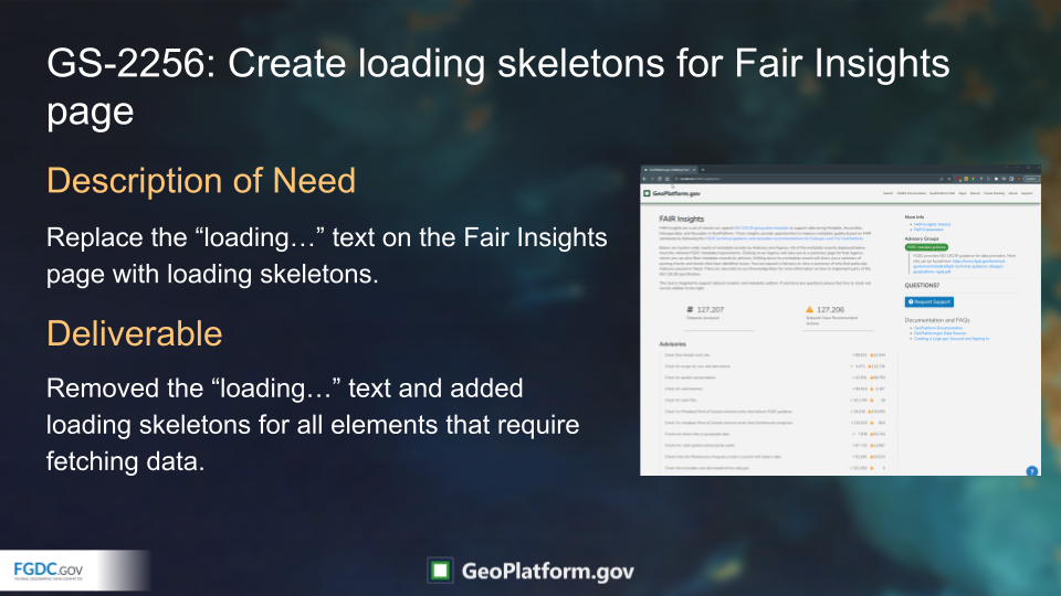
GS-2256 Create loading skeletons for Fair Insights page
GS-2491 Apply fixes to discovered 508 Compliance issues - KBase
GS-2645 Lambda Readme update: -ReharvestRegistryInformation
GS-2652 Lambda Readme update: -ExtractMetadataFromDataGov
GS-2779 remove service broker if unused
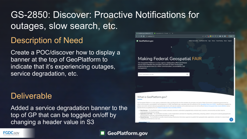
GS-2850 Discover: Proactive Notifications for outages, slow search, etc.
GS-2860 Resolve Frontend Linting Errors - Angular Core
GS-2864 Resolve Frontend Linting Errors - Search Components
GS-2866 Resolve Frontend Linting Errors - NGDA Components
GS-2887 Discover: Newbie - Guided Search option
GS-2922 Fix URLs in QACQ for automated qaqc tests against kbase
GS-2925 POC: convert ISO to DCAT (xml to json), leverage the geonetwork Java lib
GS-2926 POC: Augment ISO_JSON to add Facets to JSON
GS-2980 Capture Dat Sync / Cleanup Work
Bugs
GS-2884 Title Tag not Updated on Angular Router Activation - Registry Insights Details Page
GS-2962 Top of content is cropped on some pages
July 2023 (Version 1.58.0)
Stories
GS-2248 Combine primary search/marketplace results and insights search results components into single component
GS-2785 Rule: has-geospatial-data-links for ISO 19115-3 records
GS-2786 Rule: has-valid-vocabulary for ISO 19115-3 records
GS-2868 Resolve Frontend Linting Errors - Static Pages
GS-2928 POC: Update Opensearch stack to latest version
GS-2945 POC: Deploy Search API to SIT
Bugs
GS-2490 Apply fixes to discovered 508 Compliance issues- Portal Site
July 2023 (Version 1.57.0)
Stories
GS-2847 Backend: CSV download on search results
GS-2904 Frontend: CSV download on portfolio search results
July 2023 (Version 1.56.0)
Story
GS-2831 Add agency filters to primary search on geoplatform
Users can now filter the records based on the agency using the newly added facet option named “Agencies”. To access this, go to https://www.geoplatform.gov/search and check out the Agencies option lister under the filter on the left. 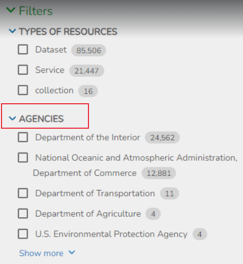
July 2023 (Version 1.55.0)
Bugs
GS-2826 Add registry insights to generate portal lambda pages
GS-2835 Browser tab shows “404” for several NGDA Theme pages
On the registry page, the browser tab will now show the title of the record instead of 404. 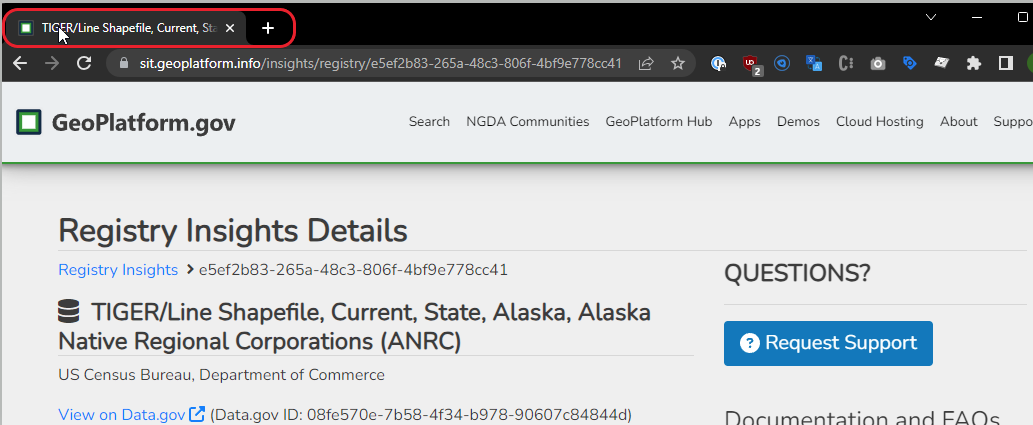
GS-2856 Add Loading Skeletons/Wheel to Metadata Details Page
Users will now be able to see a loading skeleton on the record details page when the page is loading records. To view, go to https://www.geoplatform.gov/search and click on any of the available records.
June 2023 (Version 1.54.0)
Bugs
GS-2198 Registry Page - [STG] DCAT metadata type filter is not available on the registry page as expected
The “Metadata Type” facet option is now available on the Registry Insights page. Go to https://www.geoplatform.gov/insights/registry to see this. 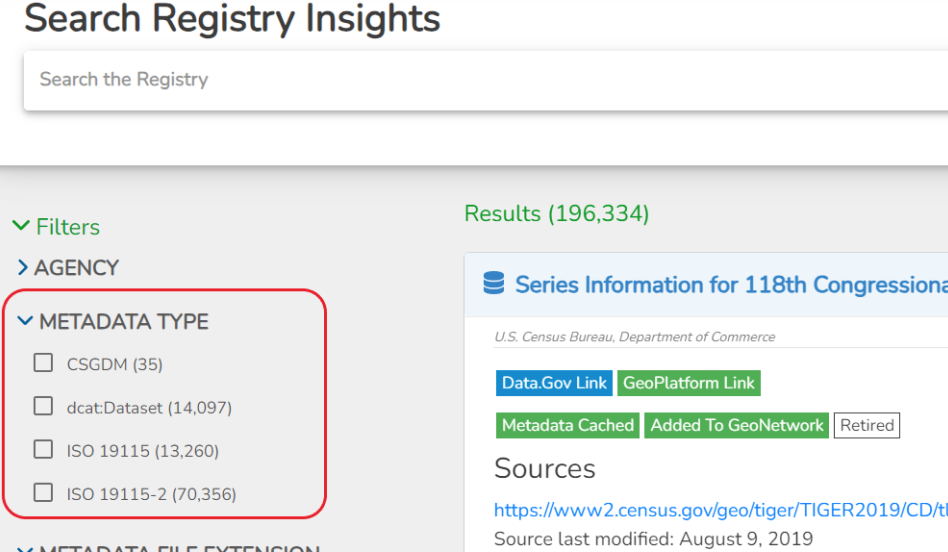
GS-2857 Re-add the 404 Error Page to the Metadata Details Page
The 404 error page functionality has been re-added to the metadata details page. The 404 page now shows correctly when an error that should show the 404 page occurs. 
GS-2879 INJECT: Allow users outside USA to access GeoPlatform
Users outside of the USA can now access the Geoplatform website. Go to https://www.geoplatform.gov/ to check that the website is accessible outside the USA.
May 2023 (Version 1.53.0)
Stories
GS-2120 Discover - Harden python requirements for geoplatform KB build
GS-2191 Delete GN records no longer in Data.gov
GS-2251 Add linter to frontend code base
GS-2419 Test -3 records in Harvest and Data pipelines
GS-2422 Develop: Enforce the ‘title’ and ‘type’ property on the definition of a STAC queryable
GS-2637 Add Static Pages to Sitemap.xml
GS-2768 Page not displaying in GP because of JSON formatter
GS-2795 ElasticSearch Cloudformation infrastructure
GS-2811 Track GP generated artifacts and display on metadata page
GS-2818 display artifact_states in the metadata page
May 2023 (Version 1.52.0)
Story
GS-2257 Create loading skeletons for Registry Insights page
Users will now be able to see a loading skeleton on the registry insights page when the page is loading records. To view, go to https://www.geoplatform.gov/insights/registry.
April 2023 (Version 1.51.0)
Story
GS-2727 Remove or hide link to NGDA cache report on FE
Removed the NGDA Import and Artifact Report from the “Geoplatform NGDA Cache Report” page. Visit https://gp-prd-us-east-1-report-bucket.s3.amazonaws.com/lmt-report-latest.html
April 2023 (Version 1.50.0)
Stories
GS-2528 Develop: Lambda for Collections import into GN
GS-2594 Update the “NGDA Theme” thesaurus name to include GeoPlatform
GS-2612 Mozilla Observatory Analysis: GeoPlatform
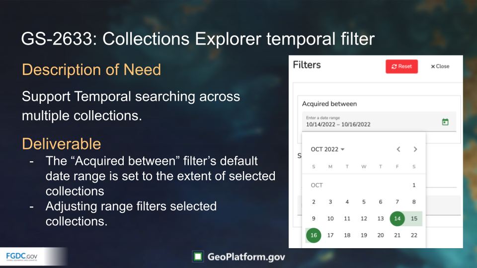
GS-2633 Collections Explorer temporal filter for multiple collections
GS-2736 Update to latest version of the STAC Fast-api
Bugs
GS-2724 remove
eo:cloudcoverqueryable from collections in pgstacGS-2745 setMetadataType error: An error occurred while executing: TypeError: Cannot read properties of null (reading ‘getMetadataFilename’)
March 2023 (Version 1.49.0)
Story
GS-2723 Replace the “?” icons for record links and files
Replaced the ? icons for record links and files. Go to https://www.geoplatform.gov/search and click on any of the records, navigate to Record Links and Files section and we can see that for each of the records and links available in that section will now have a valid and relevant icon instead of ? 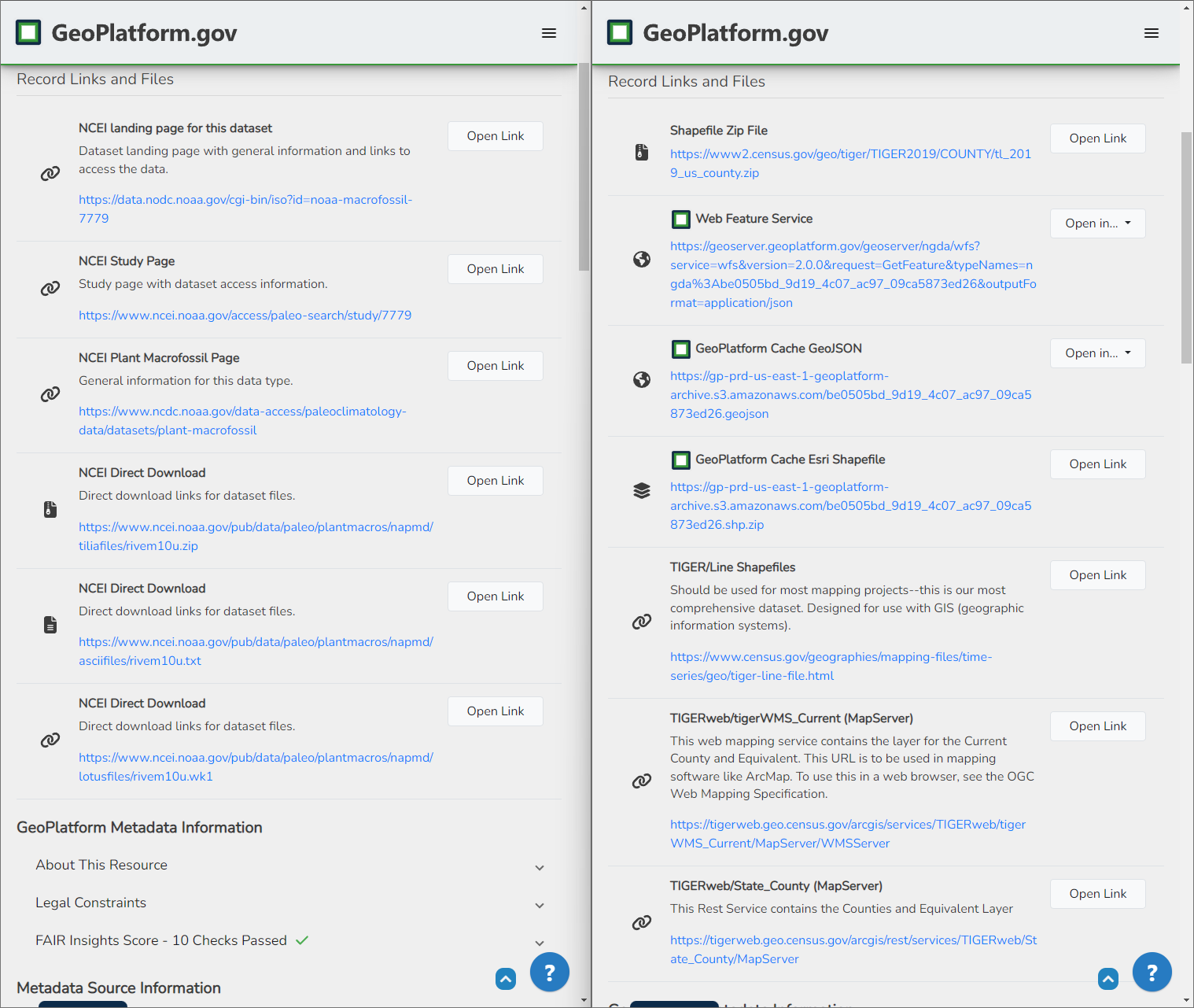
March 2023 (Version 1.48.0)
Stories
GS-2420 front end issues with the ISO 19115-1/-3 records that were published to GN
Some of the records displayed the full information in GN but not in the GP interface.We have fixed this issue and now, the site now displays full information as expected. Check https://www.geoplatform.gov/metadata/1c4976fc-268f-57d9-a273-313613791de7 
GS-2453 Registry Insights Facet enhancement
On the registry insights page, users can now multiselect the metadata types facets. 
GS-2504 Update GP Search hint
Updated the GeoPlatform Search hint text such that users can now realise that the search now does a full-text search of the metadata record titles. 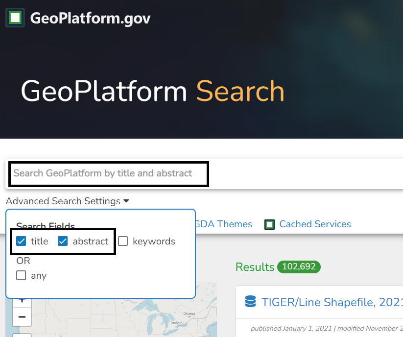
GS-2687 Redesign of footer on collections page
Revamped the footer on collection page 
March 2023 (Version 1.47.0)
Bug
GS-2505 Keywords, Tags, linked searches broken with change to default search
Added link to every keyword badge in the sidebar on the metadata page. Now searches on a metadata record page will return the correct results. Visit https://www.geoplatform.gov/search and click on any record. On the record details page, when we click on the badge listed under Keywords, it will navigate to the correct search page. 
February 2023 (Version 1.46.0)
Stories
GS-2249 - Create loading skeletons for homepage carousels
There is no indication to the users, when the carousel content on the homepage is loading. To overcome this issue, the carousel tiles will now come up as shimmering skeletons as shown below: 
GS-2530 Develop: Support Multiple Collection searching in the portal /collections page
Users can now select and search multiple collections. To see how it works, go to https://sit.geoplatform.info/collections?id=f85b73f4-8b1d-50d1-976b-fc0d50ac5abc,0a107680-29d7-5f67-aa20-26f3cf6f8752. 
By default, all collection items are returned if no collection is selected. View it https://sit.geoplatform.info/collections
GS-2559 Develop: Collections explorer pagination
Added pagination to the collections page. Visit https://sit.geoplatform.info/collections and select a collection with more than 50 results (Example: https://sit.geoplatform.info/collections?id=95bd87aa-5a92-5665-87e6-ef71e96bb024 ) . Scroll to the bottom of the results and paginate through them using the next/previous buttons.
Bugs
When users clicked on any of the menu items on top, the button or menu that was selected was not highlighted. This made it difficult for users to identify which menu they were currently at. To overcome this issue, we have updated the button styling on the navbar to show a blue underline under the selected button.
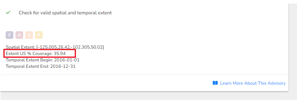
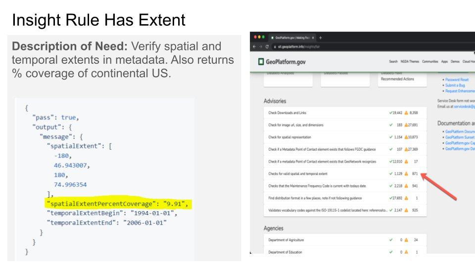
The Spatial Extent rule will now display the rule output. Visit, https://www.geoplatform.gov/insights/fair/metadata/bf488cef-432e-5e99-ad35-9b66a27b1124 and click “Check for valid spatial and temporal extent” rule. The extent values will now be populated as shown below.
February 2023 (Version 1.45.0)
Stories
GS-2405 POC: Badge or GeoPlatform searchbox available on other sites
GS-2557 Ensure that waf2stac completes topo map vector run in fargate container
GS-2563 Gather Search Feedback from users
GS-2608 Implement repair script for census
Bug
GS-2503 Harvest Census records
January 2023 (Version 1.44.0)
Stories
GS-2550 Discover: How to pass PIV x509 cert information from Login.gov to Angular frontend
GS-2555 capture agency in waf2stac collection provider
GS-2556 Add proper error checking around all uses of DOMParser.parseFromString()
GS-2558 Fair Insights UX: Replace “X Datasets Passed” with “X Datasets have no recommendations”
Bugs
GS-2451 Restructure Item Asset according to spec
January 2023 (Version 1.43.0)
Stories
GS-2471 Rule: 004-downloads-and-links for ISO 19115-3 records
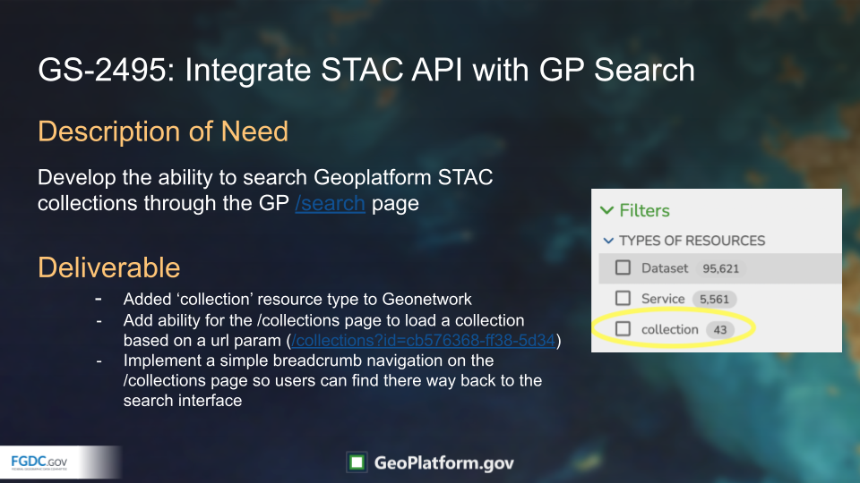
GS-2495 Develop: Integrate STAC API Collection searching with /search page
GS-2506 Update Cloud Hosting Document [GPSD-2654]
GS-2536 Discovery - The National Map Topomaps collection
Bugs
GS-2488 Update NGDA Theme Keyword
GS-2543 BackupLMT lambda not writing db dump file
GS-2551 Update link to NGDA Portfolio Community site to new Hub site
December 2022 (Version 1.42.0)
Stories
GS-2185 Develop - Implement new Metadata Details page in Frontend Portal
GS-2511 Make Collections Explorer Mobile Friendly/Responsive
GS-2531 Add UI elements to repair duplicates
GS-2533 Census waf2stac cli module for collection NDJSON
GS-2538 generate collections.ndjson from individual collections.json files
Bugs
GS-2510 Lat Lon Filter on Search Page Is not Drawing Bounding Box
GS-2518 Frontend fails to render on all Safari-based browsers
GS-2519 Collections Temporal Extent Structure
GS-2521 Rule: has valid vocab template not displaying correctly
November 2022 (Version 1.41.0)
Stories
GS-2352 Create a Census STAC Catalog similar to national maps
GS-2401 Align style of Demos/apps to homepage
GS-2439 Support multi-word keywords in search
GS-2443 Update Rule and Documentation: Checks for direct links to geospatial data
GS-2455 Get static National Map STAC Catalog into prod
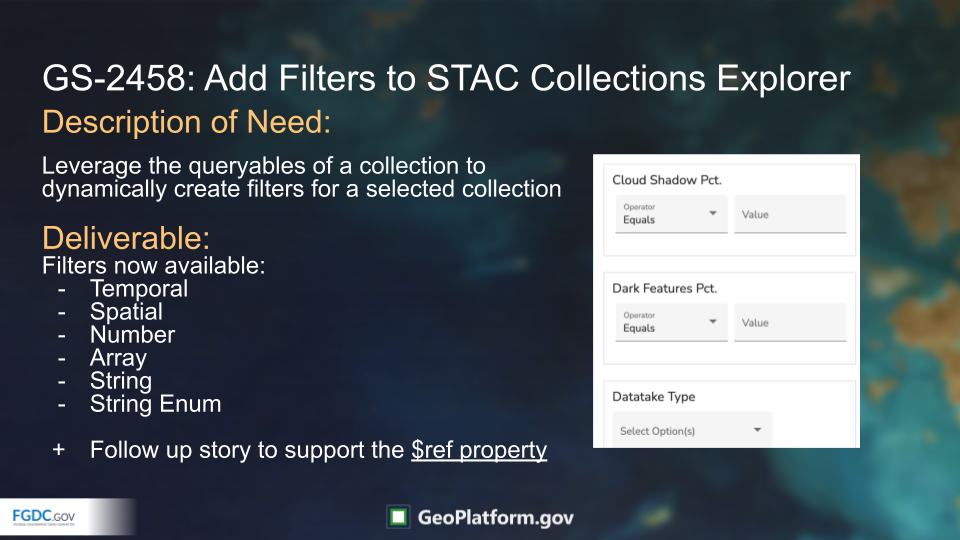
GS-2458 Add filters to STAC collections explorer
GS-2460 Remove NDJSON features and collections without features
Bugs
GS-2267 Duplicate Census Record in GP
GS-2337 Update Rule: Validates vocabulary codes against the ISO-19115-1 codelist
GS-2412 BLM Records not updated in GP
GS-2425 Error in sitemap container: xmlParser.parseStringPromise is not a function
GS-2427 Error in ReportDataSources lambda: Cannot read property ‘split’ of undefined
GS-2440 KB incorrect link in Rule: Checks for valid spatial and temporal extent
GS-2454 Robots.txt on frontend have deny all in its definition
GS-2457 STAC API bad request on /search endpoint
GS-2493 waf2stac Fargate container crashed on startup
GS-2512 Rules template renderer throws error on object key/value iteration
November 2022 (Version 1.40.0)
Stories
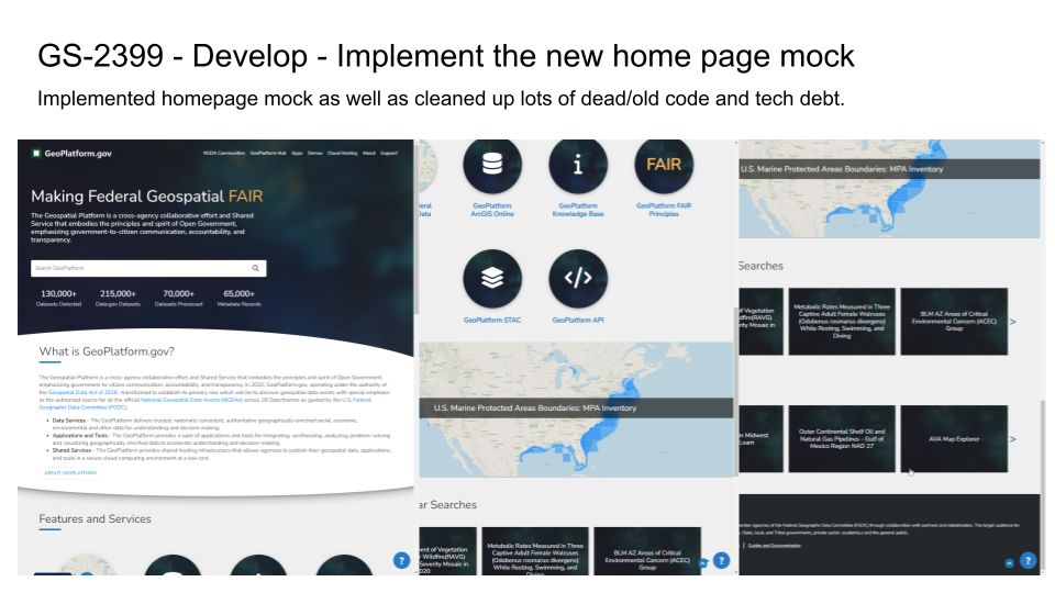
GS-2399 Develop - Implement the new home page mock
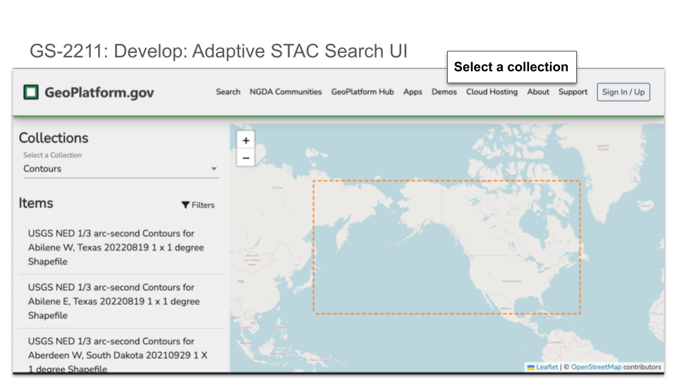
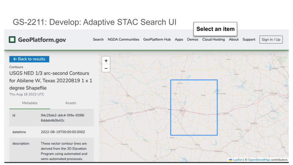
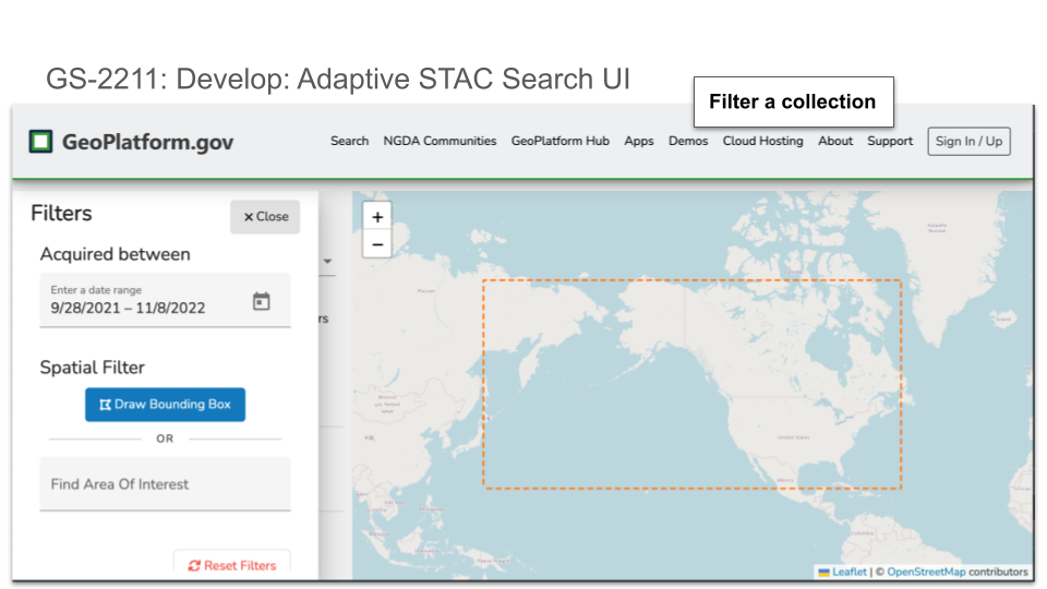
GS-2211 Develop: Adaptive STAC Search UI
GS-2429 Save WAF2STAC static files as intermediate output usable for PG-STAC
Bugs
GS-2377 registry insights not displaying “link to source”
GS-2402 Duplicate Census Records
GS-2409 Homepage - On smaller screen, the menu items are not listed properly
GS-2410 Record’s resources displayed in GN not in GP
GS-2432 Search Page - Console Error
GS-2441 Update Rule: Checks for valid spatial and temporal extent
October 2022 (Version 1.39.0)
No notable updates
October 2022 (Version 1.38.0)
Stories
Min/Max Zoom Scales to LMT
Terriamap now configured to post and get saved share link configurations from s3 using out of the box accessKeyId and secretAccessKey for S3 access.
AND functionality within search
GeoPlatform search uses an OR operator to search terms across title, abstract and keyword fields. The result of using the OR across multiple fields increases the number of search results returned as words are added to the search term. Instead of increasing the search result count as new words are added to the search term, fewer results should be returned to the user. An AND operator may be used to decrease the number of search results returned as the user adds words to the search term.
Bugs
Has Image rule doesn’t handle SVG
An SVG browse graphic causes an exception in the has Image rule. The FGDC guidance does specify JPG or PNG but GN displays the SVG. Create an error for the rule that specifies that SVG is not a supported format.
Review Logging use
Adjust non-fatal errors to use logger.warn instead of logger.error to prevent unwanted cloudwatch alarms and for general code cleanup.
LSIB Rank not working
Some of the MVT tiles were not showing the RANK as expected. This has been fixed and now we can see the RANK as expected. This can be viewed on this record.
September 2022 (Version 1.37.0)
Stories
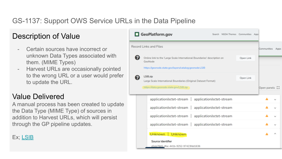
GS-1137 Support OWS service URLs in the Data Pipeline
GS-1999 Develop - Sitemap Lambda
GS-2338 Update Rule: Checks for direct links to geospatial data
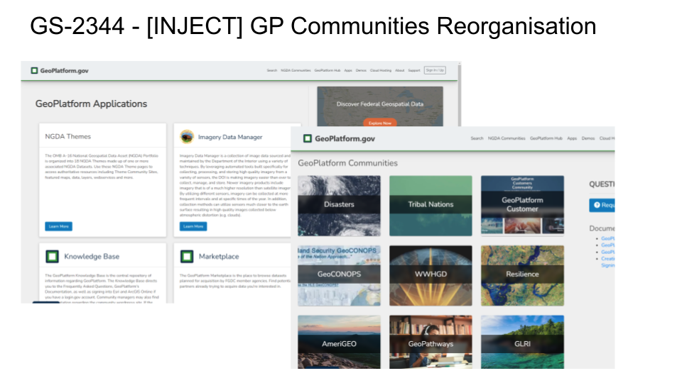
GS-2344 GP Communities Reorganisation
GS-2364 Sitemap Lambda - Cloudfront work
Bugs
GS-2216 NGDA’s out of date
GS-2269 GeospatialMetadataScorer Error: Runtime exited with error: signal: killed.
GS-2324 Typo in Rule: “Checks that the Maintenance Frequency Code is current with todays date.”
GS-2372 Google Analytics not capturing casual user experience
GS-2380 UpdateLMTNGDA failing with out of memory error
September 2022 (Version 1.36.0)
Stories
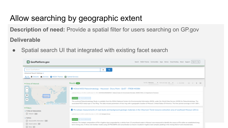
GS-2105 Develop - Allow searching by geographic extent.
GS-2139 Registry Insights Search Typeahead Fixes/Enhancements
GS-2237 Develop - Fuzzy search of possible duplicate/closely related records
GS-2327 Develop: Run FAIR Insights against metadata file
GS-2359 ADD Event to GeoPlatform Home Page
GS-2361 [INJECT] Add download tracker to GAnalytics of metadata links
Bugs
GS-2197 Metatag.io - certain records results as undefined instead of the record name.
GS-2228 KB - The Geoplatform logo needs to be updated so that it is more clear.
GS-2312 Homepage - Search is not working when we search for the keyword manually
August 2022 (Version 1.35.0)
No notable updates
August 2022 (Version 1.34.0)
Stories
GS-2069 Search: Add link to a theme’s data page
GS-2165 Apply Frontend SEO Lambda to static pages
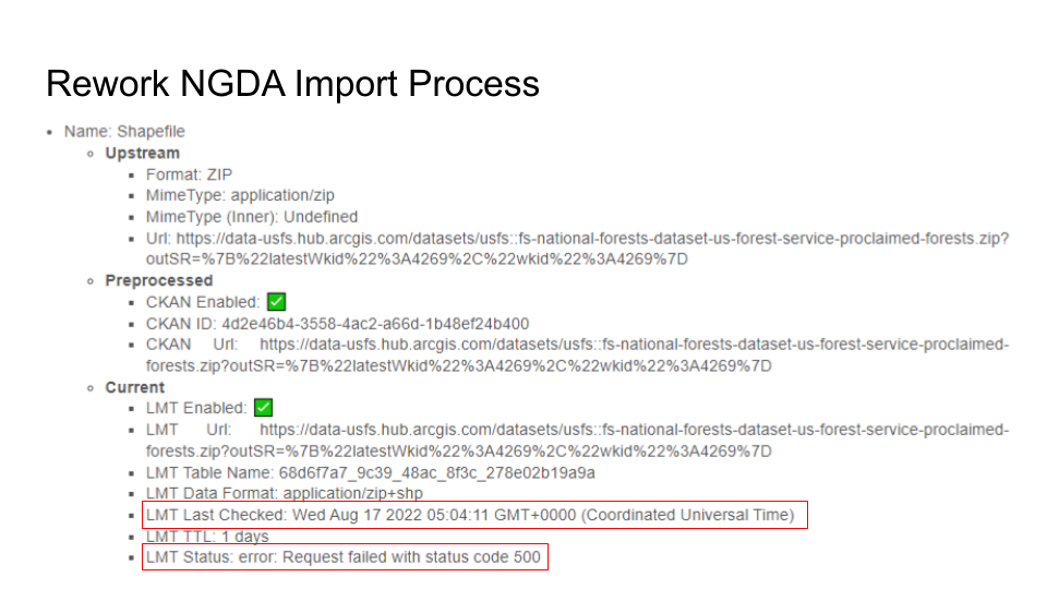
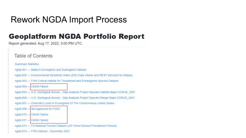
GS-2232 Rework NGDA Import due to data.gov re-indexing
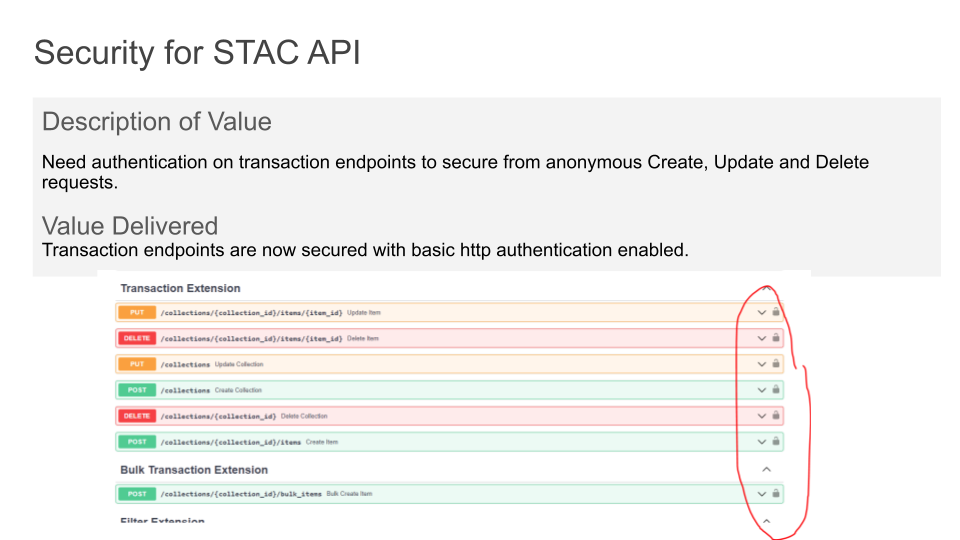
GS-2315 Develop: Security for STAC API
GS-2348 Registry Insights Enhancement - Typeahead Suggestion endpoint
Bugs
GS-2141 Kbase - Certain links on the kbase are broken
GS-2270 Census record missing Gov Units Theme
GS-2326 STACApi deployment bucket
August 2022 (Version 1.33.0)
Welcome to another August 2022 release for GeoPlatform.gov.
What’s New
This sprint/release focuses on internal system improvements and hardening.
Develop a rule to check if service has a known service format name. Search metadata for service identification use of the SV_ServiceIdentification/resourceFormat/name element.
Develop passing rule for ‘in data.gov“ and “metadata tagged geospatial in data.gov” for all datasets
Upgrade terriajs v7 catalog file to v8 catalog file and test on GeoPlatform terriamap instance
Rework NGDA Import Process -
Record-oriented instead of Batch oriented
Significantly improved upstream error detection and reporting
Significantly improve duplicate record detection
Perform pre-analysis on datasets and sources
Enhance LMT updates to support synchronizing all changes and removing duplicates
Additional consistency checks on all available identifiers
Aug 2022 (Version 1.33.0)
Welcome to the first August 2022 release for GeoPlatform.gov.
What’s New
FAIR Insights Rules
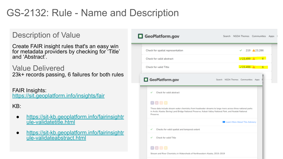
Rule - Name and Description
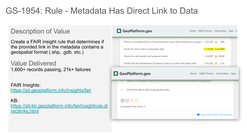
Rule - Metadata Has Direct Link to Data
STAC Catalog Schema for Shapefiles
Documentation - Linked Open Data
July 2022 (Version 1.32.0)
Welcome to another July 2022 release for GeoPlatform.gov.
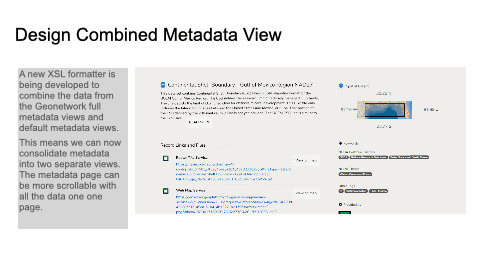
Design Combined Metadata View
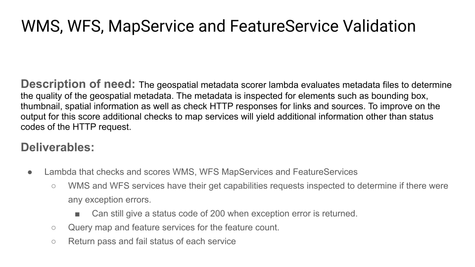
WMS, WFS, MapService and FeatureService Validation
July 2022 (Version 1.31.0)
Welcome to the first July 2022 release of GeoPlatform.gov.
What’s New
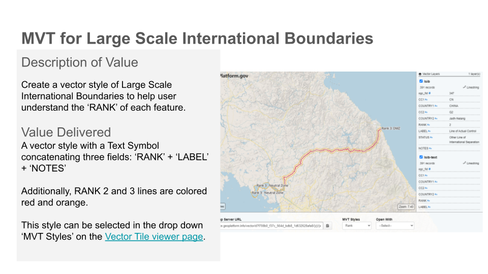
Create a vector style of Large Scale International Boundaries to help user understand the ‘RANK’ of each feature.
June 2022 (Version 1.30.0)
Welcome to the final June 2022 release of GeoPlatform.gov.
What’s New
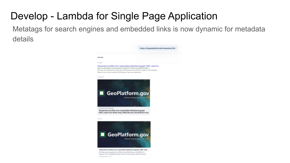
Develop - Lambda for Single Page Application
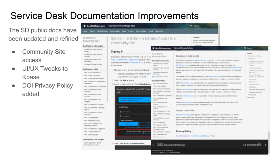
Service Desk Documentation Improvements
Add “Support” link to geoplatform main nav

June 2022 (Version 1.29.0)
Welcome to the first June 2022 release of GeoPlatform.gov.
What’s New
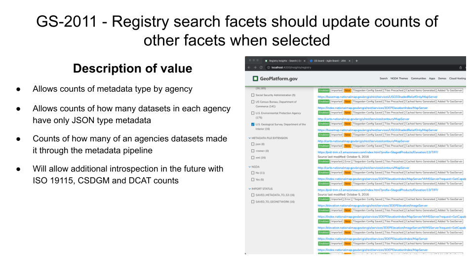
Registry search facets should update counts of other facets when selected
Design - Deeper Validation of ESRI Map and Feature Services
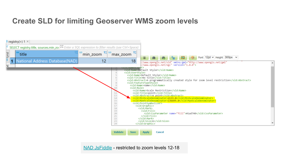
Create SLD for limiting Geoserver WMS zoom levels
May 2022 (Version 1.28.0)
Welcome to the final May 2022 release of GeoPlatform.gov.
What’s New
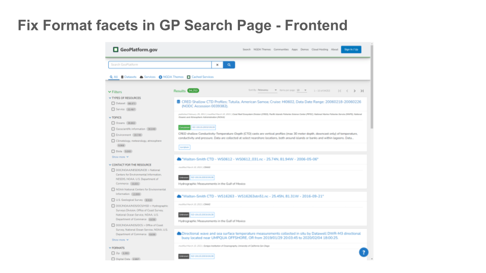
Fix Format facets in GP Search Page
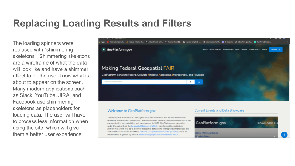
Replacing Loading Results and Filters
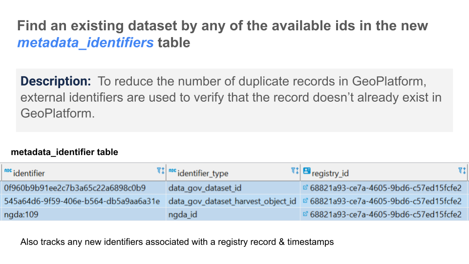
Reduce the number of duplicate records in GeoPlatform
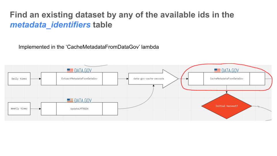
Lambda and queue to re-harvest registry information from data.gov
Lambda to Identify type of metadata ISO, CSDGM, DCAT
Add TerriaMap OpenAPI configuration to rapidocs
May 2022 (Version 1.27.0)
Welcome to the first release for May 2022 of GeoPlatform.gov.
What’s New
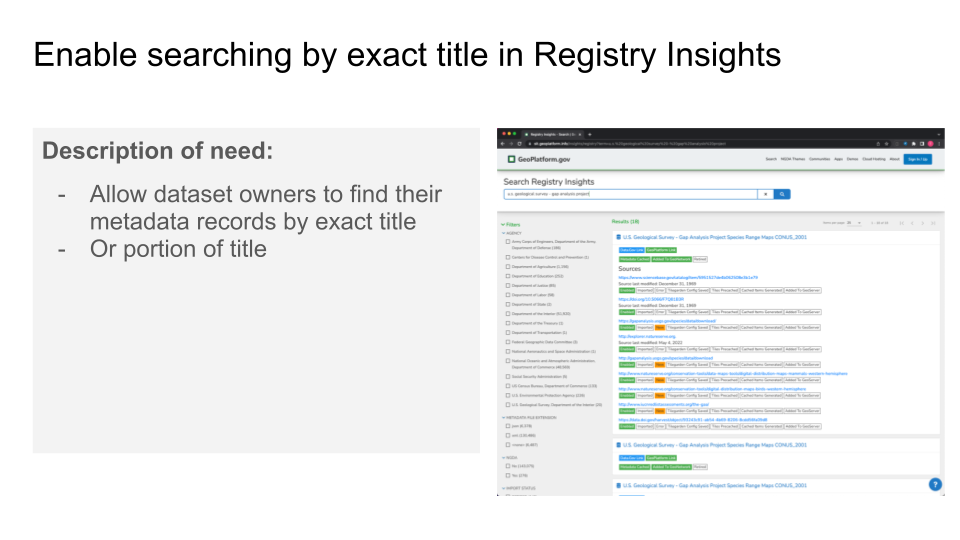
Enable Searching by exact title in Registry Insights
Provide Better
Insightsthrough improved harvesting Errors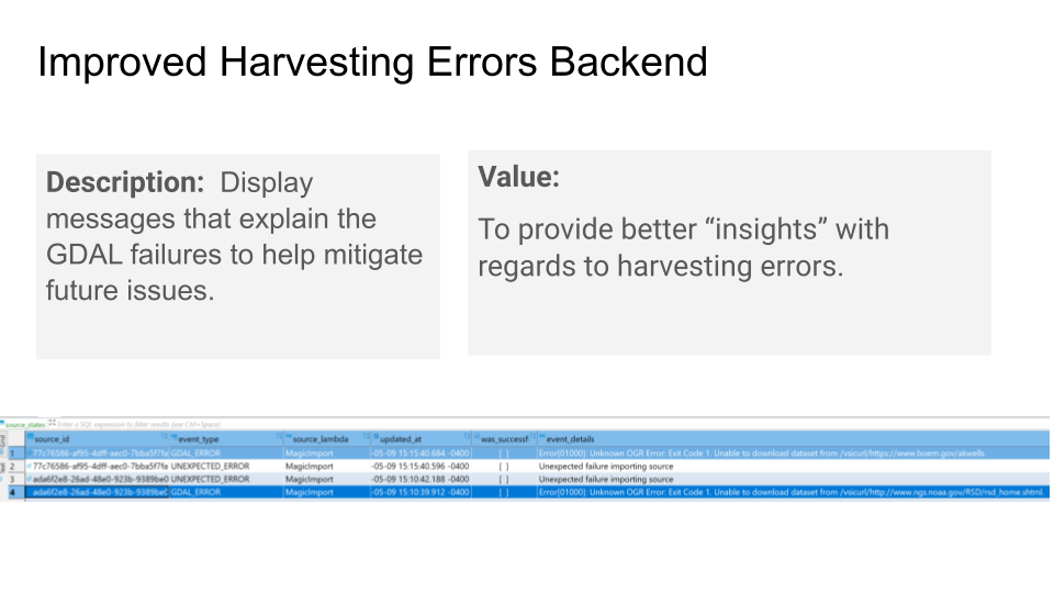
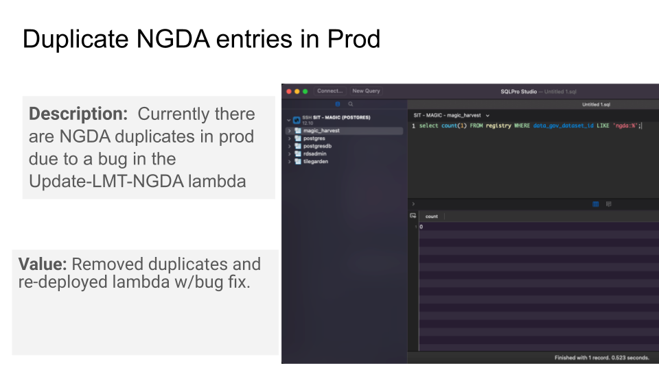
Identify and remove duplicate NGDA entries in GeoPlatform
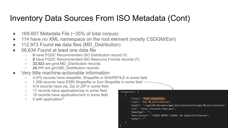
Inventory Data Sources From ISO Metadata
Bug Fixes
Search Page - Certain formats were not displaying records upon selection
April 2022 (Version 1.26.0)
Welcome to the final release for April 2022 of GeoPlatform.gov. While you might not see any changes to GeoPlatform for this release, we have made a number of improvements under the hood.
What’s New
Search Results We’ve been working on improving GeoPlatforms Search Engine Optimization (SEO). This means that when someone searches on Google or Bing for GIS data that we make F.A.I.R., GeoPlatform will better be represented in the list of search returns.
Group Facets for file/data formats - This Normalize data formats into well-known names and allow faceted search on that name. It also provides the framework for future search improvements

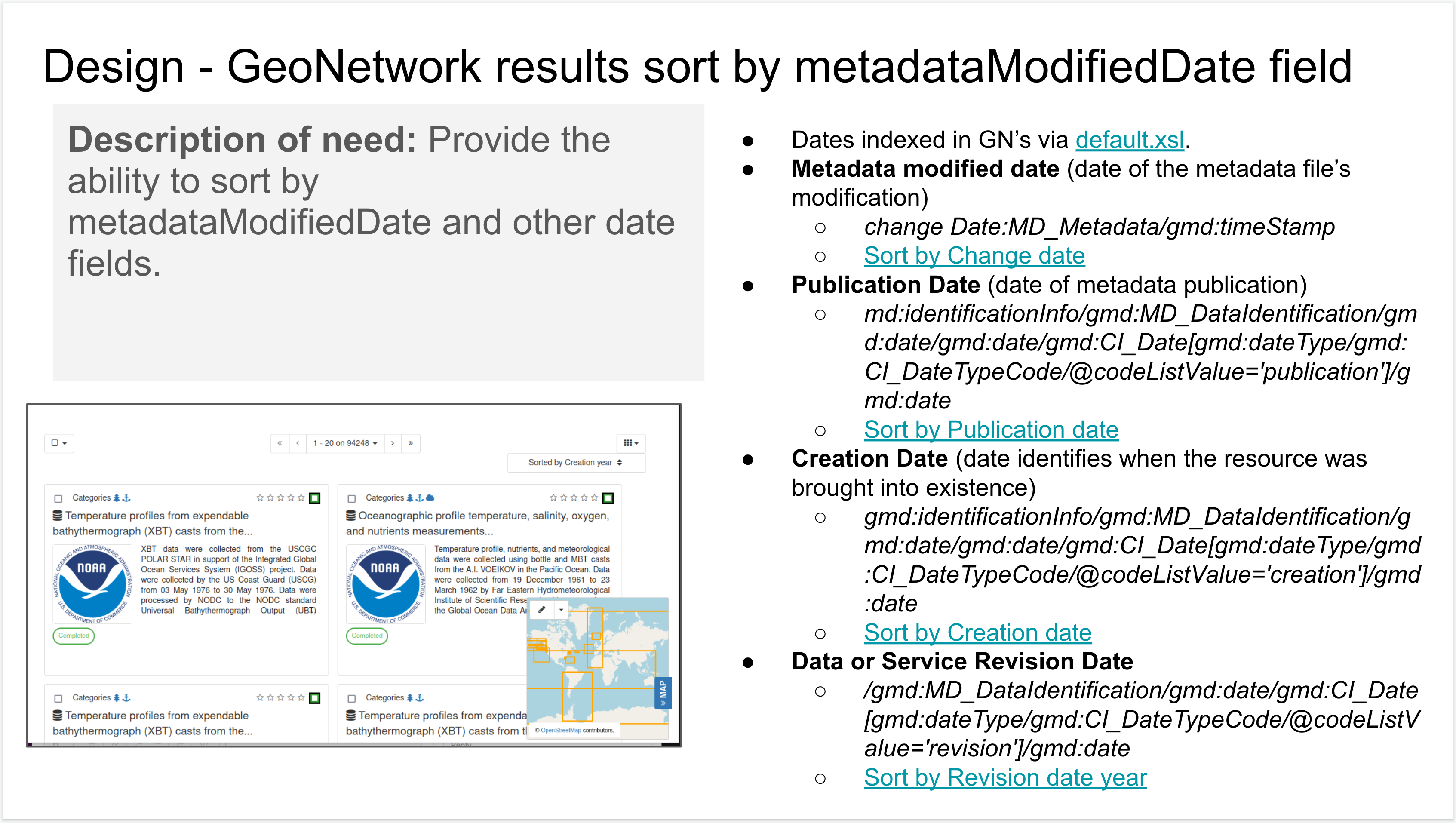
Sorting returns by the modifieddate field of the file metadata.
Bug Fixes
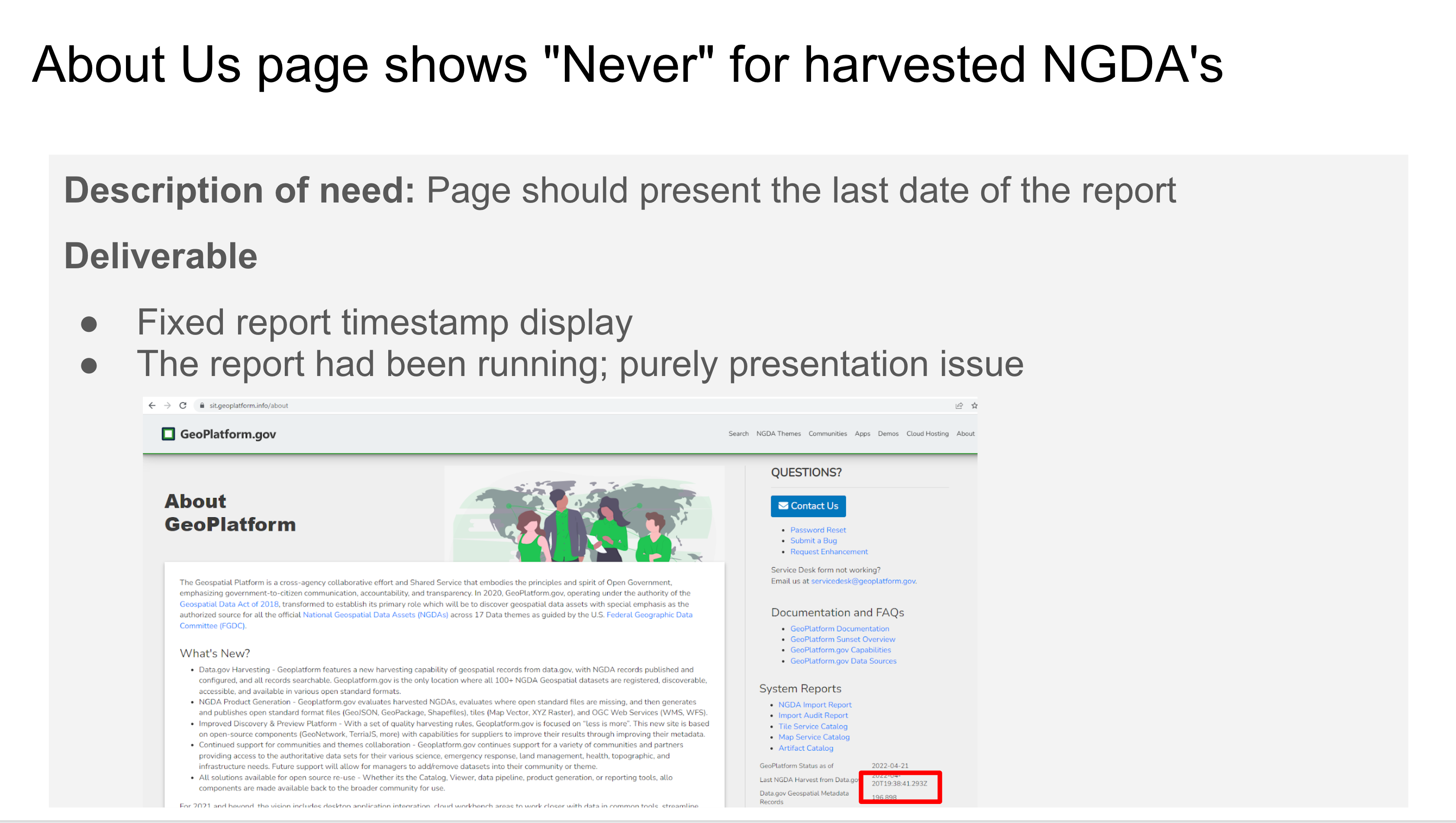
Fixing the “Never” for harvested NGDA’s on our About Page.
Coming Soon
An all new GeoPlatform Site Stats Page
More Search Improvements
April 2022 (Version 1.25.0)
Welcome to another April 2022 release of GeoPlatform.gov. We’re proud to annouce an all new GeoPlatform Knowledge Base application (and retirement of the old one) along with a few notable bug fixes.
What’s New
An all new GeoPlaform Knowledge Base (aka KBase) powered by Sphinx. Anything you need or want to know about GeoPlatform, but were afraid to ask (or just didn’t know where to find it). New documents and faq pages are coming out soon, so keep coming back for updates.
Notable Bug Fixes
The legacy Login.gov page has been updated with a new message for content editors.
When typing in the search bar, results populate the page before the user would hit
enter. This no longer happens.Action buttonshave been added to the Sources section of the Registry Insights details page to Expand or Collapse the Source rows to make it easier for users to review data sources.
Coming Soon
An all new GeoPlatform Site Stats Page
April 2022 (Version 1.24.0)
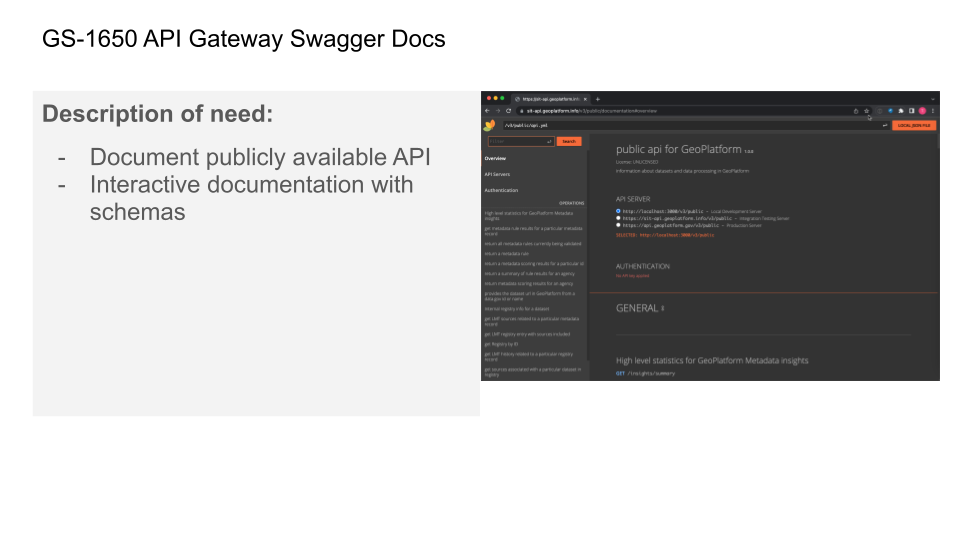
Welcome to the first April 2022 release of GeoPlatform.gov. Exciting new additions includes API Gateway Swagger Documentation and CQL lookup in GeoNetwork.
What’s New
API Gateway Swagger Docs - This documentation API is now publicly available API and Interactive documentation with schemas
Notable Bug Fixes
GPSD-2159: BLM Survey123 Connect Login Issue - Allows BLM Staff the ability to log into Survey123 Connect with GeoPlatform ArcGIS Online login
Demo Page - Filter by Type “Demo Example” would not filter the results as expected.
Coming Soon
New Knowledgbase powered by Sphinx
March 2022 (Version 1.23.0)
Welcome to the March 2022 release of GeoPlatform.gov. Excited about some new tools being released this month and improvements to our FAIR Insights: Climate & Economic Justice Screen Tool Release - The Justice40 Initiative was created by the Biden-Harris administration, against the backdrop of economic and climate crises, to fulfill its campaign promise to ensure that at least 40% of federal climate investments go directly to frontline communities most affected by poverty and pollution. https://screeningtool.geoplatform.gov/en/ New FAIR Insight Rules - We are continuing to add additional rules to support data being Findable, Accessible, Interoperable, and Reusable in GeoPlatform.
FAIR Insight Rules
Rule: Has Extent (GS-1569)
Notable Fixes
GS-1617 Metadata Source Types are not being recorded for use within GeoPlatform and some search improvements
GS-1472 General SEO Improvements
GS-1376 Improvements to download links for geospatial files
Coming Soon
GS-1473 Quicksearch feature for Chrome in the URL by pressing TAB
March 2022 (Version 1.22.0)
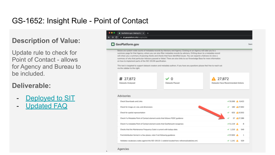
Welcome to the March 2022 release of GeoPlatform.gov. Excited about some new tools being released this month and improvements to our FAIR Insights: New FAIR Insight Rules - We are continuing to add additional rules to support data being Findable, Accessible, Interoperable, and Reusable in GeoPlatform.
FAIR Insight Rules
Rule: Point of Contact (GS-1652)
While there are many opportunities within the ISO metadata record to identify contacts, the inclusion of a Point of Contact enables Data.gov and the GeoPlatform to direct users to a single point of inquiry for the resource. To facilitate discovery by ‘organization’ within Data.gov and the GeoPlatform, the Point of Contact should be the agency directly responsible for the metadata publication. In addition to designating the publishing agency as the Point of Contact, it is important to designate the associated Responsible Party Role as ‘publisher’, as shown below.
Rule: Vocabulary/Code List (GS-1565)
This FAIR Insight rule checks for FGDC recommended code lists and that their code types are valid. Code List Vocabulary and Codes are referenced from the official ISO codelist here: https://standards.iso.org/iso/19115/resources/Codelists/cat/codelists.xml
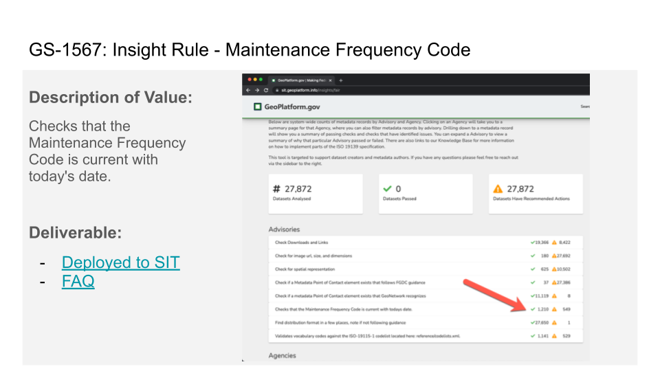
Rule: Maintenance Frequency Code (GS-1567)
Notable Fixes
GS-1663 Ability to now sort by date on GeoMarketplace
GS-1223 Improved 404 response page
Various Demo improvements (GS-1588)
Coming Soon
A new knowledge base website is being developed for April 2022
Community portals moving to Esri HUB
February 2022 (Version 1.21.0)
Story
GS-1616 DNS 301 Rewrites for new ALB
GS-1612 Save all the logs into AWStats, then search logs and run analysis
GS-1604 PRD - Registry Sources Full implementation
GS-1581 Add sources information to registry insights API
GS-1571 Insights UI Changes: Updated Text
GS-1566 Rule: Spatial Projection
GS-1563 Rule: Output distribution formats
GS-1504 Remove Frontend download link to GeoNetwork Metadata
GS-1465 Develop Open-In Feature
GS-1447 Terriamap API Gateway OpenAPI YML
GS-1420 Geoplatform API https://data.gov unique id link, Frontend / backend
GS-1405 Develop - Update preflight check to update LMT with NGDA import lambda failures
GS-1378 Develop - Create AWStats process and page for GeoServer/Terriamp CloudFront Distribution
GS-1355 For Terria config file, explore benefits and prepare demo
GS-1138 Incorrect dates in GP
February 2022 (Version 1.20.0)
Story
GS-1575 Add existence of registry insights to metadata api
GS-1555 add name and gn_id parameter to service link URLs on GP search page
GS-1524 Injection: Terriamap Config Tilegarden Table Check
GS-1505 Develop - STG / PRD Cross-Domain Keycloak vulnerability
GS-1443 Move update-pygeoapi-config lambda to pygeoapi stack
GS-1434 Roll out PygeoAPI to STG/PRD
GS-1391 Link back to Insights
GS-1386 Draft Registry Details: Sources
GS-1383 Registry: Facets Route
GS-1347 Develop - Create AWStats process and page for GeoNetwork
GS-1279 Configure CSW API
GS-942 On Homepage, a page that describes how we “Apply FAIR standards to Geoplatform”
January 2022 (Version 1.19)
Story
GS-1520 Injection: terriamap open-street-map-type URL fix
GS-1419 Release Page
GS-1389 Registry Details: Breadcrumb + Links
GS-1388 Registry Details: Shell Page
GS-1387 Registry Details: Import History (FE Work)
GS-1384 Registry: Persistence
GS-1364 Disable access to https://accounts.geoplatform.gov/register
GS-1026 Harvest Original FGDC Metadata API
January 2022 (Version 1.18)
Welcome to the ## January 2022 release of GeoPlatform.gov. There are many updates in this version that we hope you like, some of the key highlights include:
Revised Marketplace - Browse datasets planned for acquisition by FGDC member agencies. Find potential partners already trying to acquire data you’re interested in.
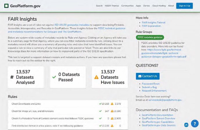
F.A.I.R. Insights Preview -
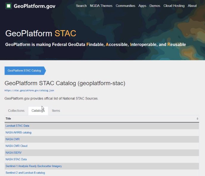
GeoPlatform STAC - The federal catalog of catalogs.
Maps Explorer Update - We are now using TerriaMap v8 which comes with some new features.
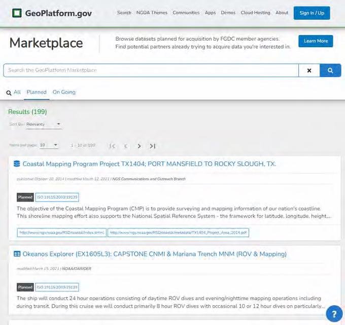
Marketplace
You can now search for “Planned” and “On Going” projects related to datasets that are planned for acquisition by FGDC member agencies. More about the program can be found here. https://www.fgdc.gov/what-we-do/manage-federal-geospatial-resources/geospatial-marketplace
F.A.I.R. Insights
Learn more about this new service at FAQ - GeoPlatform FAIR Insights
GeoPlatform STAC
GeoPlatform STAC is the catalog of catalogs. Visit: **stac.geoplatform.gov
Maps Explorer Update
Visit Site: https://terriamap.geoplatform.gov/
Notable fixes
GS-1435 HSTS Support for Terriamap
GS-1436 HSTS Support for GeoNetwork
GS-1437 HSTS Support for GeoServer
GS-1438 HSTS Support for PygeoAPI
Coming Soon
Insights Registry -
GeoAPI Support -

December 2021 (Version 1.17)
GS-1439 HSTS Support for Tilegarden
GS-1432 STAC Website App Card
GS-1418 Results PyGeoAPI PostGIS Driver issues with datasets
GS-1292 Rules Engine: Getting Started intro paragraph on Root Insights Page
GS-1291 Rules Engine: Change Branding to “FAIR Insights”
GS-1290 Rules Engine: Trigger running rules in UpdateGeonetworkMetadata
GS-1288 Rules Engine: Create FAQ pages for existing rules
GS-1286 Rules Engine: Side Panel FAQ and explanations
December 2021 (Version 1.16)
GS-1454 Injection - GeoIP plugin for AWStats OR Postscript processing
GS-1442 Develop - AWStats on GeoPlatform to read user IP addresses
GS-1430 Create the Release Document for 1.16 and get with Humberto
GS-1410 Implementation for PyGeoAPI
GS-1404 Develop - Create History Table to discriminate import history
GS-1399 Update configuration file to include metadata.json (TileJSON spec)
GS-1373 Discover - DNS subdomain routing to subfolder for New GeoPlatform Marketplace
GS-1350 PLSS V2
GS-1287 Rules Engine: CLI Tool Improvements
GS-1283 Rules Engine: Main Metadata Page Widget
GS-1281 Rules Engine: Agency Summary on Root Page
GS-972 Expose LMT Sources information in public shared API
November 2021 (Version 1.15)
Story
GS-1398 Test Case for Metadata insights
GS-1394 PLSS V2: Mapupnik demo
GS-1379 Injection: Fix LSIB Data Ingestion
GS-1370 API endpoint for metadata sources to minimize reliance on https://data.gov metadata sources
GS-1368 Add Collections to the STAC catalog for GP
GS-1359 STAC Catalog cloudfront, route53 and certificate manager
GS-1301 Terriamap minor UX changes
GS-1299 Develop - Front End Marketplace Page
GS-1285 Rules Engine: Agency Page Dataset Filters
GS-1280 Rules Engine: FAIR Flags
GS-1252 Develop - Source button and link to metadata record GP is harvesting from
GS-446 Discover - Backlog Tickets using CloudWatch metrics/alarms for existing services.
November 2021 (Version 1.14)
Bug
GS-1265 Search Page - Completed pill is displayed in two different colors
GS-1263 Search Page - Error on developer console when we click on All/Datasets/NGDA themes/Cached services tab
GS-1245 Search Page - Status filter not working
GS-1239 Error while running json tests
GS-1143 Shared API not working in STG?
Story
GS-1352 Enable Large Scale International Boundaries NGDA to cache on NGDA Import Report
GS-1349 Update Terriamap for crud_metadata (new)
GS-1294 POC - pygeoapi
GS-1284 Rules Engine: Render Rule Output on Dataset Page
GS-1282 Rule Engine: Layout Tweaks
GS-1237 Mock of ideas, 2nd iteration of Demos Page UI
GS-1183 Develop - AWStats Adjustments to CloudFront Logs
GS-1166 QA Team needs guidance on developing test case for label:frontend.portal.products.cache
October 2021 (Version 1.13)
Release notes - GeoPlatform Dev - Version 1.13.0
Bug
GS-1205 Fix permission error in PRD nightly AWStats
GS-1196 Record Detail Page - Getting 500, 503 error message on the console
GS-1184 Running lambda tests results in modified files
Story
GS-1295 Ignore conformsTo when processing DCAT records in CacheMetadataFromDataGov lambda
GS-1200 Add List to Rules Engine
GS-1195 Set up JSD help widget and integrate into portal
GS-1194 Adding GeoPlatform components back into Behind the Scenes list on Apps page. Adding IDM and Knowledge Base as two apps on the Apps Page
GS-1193 Injection: Discovery: Match theme on powerpoints, app page, github, etc.
GS-1188 Terriamap Lambda Catalog Update
GS-1186 Data Formats FAQ available on Rules Engine
GS-1176 Develop Rules Engine UI - Export dataset lists
GS-660 Develop Rules Engine UI - Home Page Stats
October 2021 (Version 1.12)
Bug
GS-1190 Fix update-lmt-ngda lambda to allow reports to run
GS-881 Issues on Story Editior - Terriamap
GS-731 Terriamap buttons having the wrong color and poor contrast Story
GS-1177 Remove Australian Disclaimer on Terriamap
GS-1127 Develop Rules Engine UI - Agency Page
GS-1032 Terriamap - Adding dataset using Add Local/web data
GS-678 Develop Rules Engine - Rule TBD to develop Runbook
GS-507 Viewer - 404 Page for Terriamap needs a rewrite
September 2021 (Version 1.11)
Bug
GS-1153 QA/QC bot not posting to private-test-team channel
GS-727 Terriamap CSS Add Data - No URL specified under Data URL
Story
GS-1123 Create sidecar entry for Geographic Names Information System (GNIS)
GS-1086 Develop Rules Engine UI - insights page
GS-906 Develop - Create an Index and Thesaurus for GeoNetwork’s Q search to better filter the NGDA themes
GS-884 Develop Rules Engine - Create an API for summary pages of rules engine results
September 2021 (Version 1.10)
Story
GS-1171 Injection: image fix for Reports
GS-644 Develop Rules Engine - Add some additional fields to Rules Engine to support consistency between environments
GS-643 Develop Rules Engine - Grab dataset Agency from Data.gov and store in LMT
August 2021 (Version 1.9)
Story
GS-1114 Design - Way to split out lambda stack IAM permissions
GS-1070 Utilizing AWStats with S3 websites logs
GS-903 Port demo explorer widget
GS-792 Create POC of transform to support tabular source such as CSV, XLS or XSLX with geo points as source from https://data.gov
August 2021 (Version 1.8)
Bug
GS-1054 Identify timeout issue with Keycloak codebuild
Story
GS-1084 Deploy PostGIS-indexed GeoNetwork to PRD
GS-1079 Geoplatform NGDA Cache Report: User sees cached page and assumes report has not ran
GS-1043 NGDA Themes pages Needs link to official Portfolio list
GS-894 NGDA Portfolio View Report
GS-851 Support downloading from FTP sites - Omernik’s Level III Ecoregions Of The Conterminous United States
GS-804 Terriamap service names for non-NGDA datasets
GS-765 CRON for QA/QC Tests
GS-436 Update Registry Table and Models for Tags
July 2021 (Version 1.7)
Story
GS-1073 Update LMT Lambda to Support New FGDC NGDA Spreadsheet Format
GS-1052 All reports linked to About Us page need to run nightly
GS-1050 Homepage widget/About page add a “Last Harvested” date.
GS-870 NAD: Complete Logic map table to support over-riding default zoom level governance
GS-513 Create a field/tag in the logic map table to drive a generated run list (BlockedList or AllowedList) for large or non-conforming ISO19139 metadata xml files
July 2021 (Version 1.6)
Bug
GS-979 Tilegarden not precaching zip code layer correctly
Story
GS-1046 Investigate rendering of Treasure Island for USDS
GS-986 Coordinate Login.gov app promotion
GS-915 Implement AGOL Keycloak IDP
GS-896 NGDA Retirement - remove from magic_harvest and geonetwork
GS-878 Upgrade from aws/codebuild/standard:3.0 image
GS-680 DCAT 1.1 full metadata reference will expose more records, pull ISO from the DCAT per the “1.1”
GS-562 Viewer - Terria Map links go to wrong links (current live or aussie map site)
June 2021 (Version 1.5)
Bug
GS-969 The Data size mentioned on the homepage is 874 MB but Data volume mentioned on the About page is 834 MB.[Please confirm whether these two count represents the same]
GS-968 On About page, for Tile Service Catalog, the page opens as expected but the title was displayed as Artifact Catalog
GS-967 On About page, for NGDA Import Report, the page does not have logo.
GS-941 Set GeoNetwork health check grace period to higher value
GS-693 ExtractMetadata generating duplicates in cache queue
Story
GS-966 Website S3 Logging
GS-964 Collect hits/views per month for new Geoplatform
GS-922 Part 2 - PopulateTileGarden Config Scale Support
GS-858 Part 3 - Set allowed zoom levels in Tilegarden for certain datasets
GS-855 Data Pipeline Investigation - BLM National Public Land Survey System Polygons
GS-853 Data Pipeline Investigation - Outer Continetal Shelf Block Aliquots
GS-852 Data Pipeline Investigation - BOEM Seismic Water Bottom Anomalies
GS-323 Login.gov/KeyCloak - GP Diagram
GS-283 Capture the Original Spatial Reference of a Dataset
GS-61 Handle bounces/complaints from SES
June 2021 (Version 1.4)
Bug
GS-961 https://www.geoplatform.gov/ results in bad gateway error, potential legacy server issue with Zivaro
GS-934 Terriamap API Gateway Issues
GS-751 WMS need to be registered on full metadata pages and searchable
Story
GS-937 Search Results Page - Add Tab for GP Generated Formats
GS-912 Verify ArcGIS support multiple identity providers
GS-838 Coordinate Test of new setup for Zivaro Keycloak hosting
GS-739 User, Role, Group Design
GS-497 Include infrastructure environment tag in report email subject
GS-282 Design retry logic for PreocessNGDAChanges in presence of recoverable errors
June 2021 (Version 1.3)
Bug
GS-924 Nightly report running but not updating date on about page
GS-910 Tile Service Catalog links route to bad URL
Story
GS-916 Generate AGOL Mailing List to guide outreach
GS-911 big demo opportunity for GP On ## June 30. Coordinating with NGA on climate data and geoplatform.
GS-877 Re-index Lucene after generating GP MAGIC products/service
GS-873 Part 1 - Investigate way to harvest min and max zoom levels from sources
GS-822 Demos: Standing Stack and features and ## Maybe showcase other use
GS-821 Demo: Discover Fed Geo Terria Showcase
GS-742 Design Iteration reviews - Red (AGOL: Workflow, Account Clean, Storage Clean, Compute Clean)
GS-353 Legacy sunset cutover checklist/plan approved
GS-319 Keycloak and Legacy gpoauth sequence diagrams for authentication flows Diagram
June 2021 (Version 1.2)
Bug
GS-910 Tile Service Catalog links route to bad URL
GS-850 Generating Tiles for files not in catalog or failed in harvest
GS-674 Terria Map Viewer - Transparent png from USGS National Map Topo Basemap is showing dark blue
Story
GS-856 Retire datasets - Census Bureau Regional Office Boundaries & Army Military Land Tracts (AMLT)
GS-835 Improve System Stats Presentation
GS-830 Create HIFLD WordPress Community Container
GS-729 Results Page - Make sure the URL cannot be hijacked
GS-669 New Login/Sign-up Page Flow
GS-658 Demo Results View for Metadata Facts Presentment
GS-634 Document auto-recovery configurations for containers
GS-609 Cache - Resolve Tilegarden tile serving hardening issues (e.g. broken tiles on-demands )
GS-537 General - Investigate TLS 1 usage for gp.gov
GS-525 Document process in wiki for syncing NGDA updates to LMT
GS-392 Legacy - Confirm if any non datagov records that are in RegP need to sideCar load via RegP Migration Records
GS-377 Investigate OE names issue
GS-291 Audit/Shadow CCB User Reports to Prod related to
GS-204
GS-290 Audit/Shadow User Accounts Report to Prod related to
GS-204
May 2021 (Version 1.1)
Bug
GS-846 Geoserver I/O error on map preview
GS-817 CORS error on STG and PRD for the latest system stats (on the About page)
GS-764 PostGIS connection issue in precacher
GS-763 UpdateGeonetworkMetadata queue processing too slow
GS-748 Tiles on demand arent working consistently and auto testing not catching it
GS-484 RegisterNGDAGeoserver λ: Switch out Admin credentials to a less priviledged user Story
GS-876 Update Raster and Vector Tile links to include name and gn_id parameters
GS-847 Improve the readability of the initial linked reports
GS-834 Fix Keycloak in PRD
GS-814 Kortoza implemented into prod
GS-813 OMB EOP SFTP
GS-811 Set Default Base Map
GS-805 SFTP Account Setup for BOEM
GS-793 DNS for Kartoza GeoServer
GS-699 Need Harvest Report published nightly and linked from About us and Apps/Demos page
GS-629 Document account/pw keep checklist and gain approval on how this is documented
March 2021 (Version 1.0)
Bug
GS-713 Validate error - TerriaMap only loads the NPS Base Map in Chrome
GS-662 GeoNetwork - PopulateServicesAndDistributionsGeonetwork issues
Story
GS-724 Turn off Year filtering rule for unpublished - allow records to be published
GS-709 Make ProcessServicesBroker bucket private
GS-705 Clone portal from prd to test banner changes
GS-702 Address unwanted GeoNetwork health check restarts
GS-700 Terria - Terria - do not show skeleton, only show where have tiles generated, remove the 2nd tier
GS-696 GeoNetwork - Optimize GeoNetwork CPU/RAM per environment
GS-675 General - Replace s3-sync serverless plugin with AWS cli usage
GS-664 General - Accumulate all STG and PRD DNS records
GS-663 Metadata Pipeline - GeoNetwork + Data.gov troubleshooting
GS-661 GeoNetwork - Capture failed records during GeoNetwork downtime
GS-655 Metadata Pipeline Updates for Audit
GS-654 Metadata Pipeline Updates for Artifacts
GS-648 GeoNetwork - Reprocessing Task
GS-647 Metadata Pipeline - Reset, run pipeline in staging
GS-618 General - Let Frontend know (GPV2-69) - when they can officially add the banner messages to announce/link to new beta site
GS-610 General - Fix public flag issue limiting WMS/WFS stability
GS-607 GeoNetwork - load all unpublished metadata into GeoNetwork
GS-606 Metadata Pipeline - Capture signoff and acceptance of “changed files” test
GS-605 Metadata Pipeline - Datagov - Handle https://data.gov UUID changes/clean-up
GS-604 GeoNetwork - Validate metadata harvesting w/ EU validation disabled
GS-602 Metadata Pipeline - Find a way to get harvest_object_id from another API
GS-595 Metadata Pipeline - Streamline Data.GOV api calls in metadata fetching lambdas
GS-589 General - GeoServer Public Access
GS-587 Leaflet preview does not display details
GS-583 Metadata pipeline - visibility for Dispatch events (PrecacheTilegardenLayers)
GS-575 GeoNetwork - Change default GeoNetwork admin passwords
GS-549 Metadata Pipeline - Update extra.json file to cleanly import all NGDA datasets from scratch
GS-548 General - Infra Production deployment
GS-545 Metadata Pipeline - LoE: Bring in/Show Original FGDC Metadata by ISO option
GS-543 Metadata Pipeline - Save Cached Filename in Registry Table
GS-542 General - Data Pipeline - Production deployment
GS-539 Metadata Pipeline - Harvest Load congressional data into staging
GS-523 GeoNetwork - Address alarm: PopulateServicesAndDistributionsGeonetwork
GS-473 Add domain and domain mapping for API Gateway
GS-467 Metadata Pipeline - Enable certain sources on import in update-lmt-ngda lambda based on ruleset
GS-416 General - star.geoplatform.gov 2020-2021 expires 3-12-2021
GS-58 Metadata Pipeline - Test Metadata Lambdas with CKAN 2.8
Task
GS-708 Validate S3 buckets Perms: Public or restricted (Parallel item)
